

Allegany County
MDGenWeb

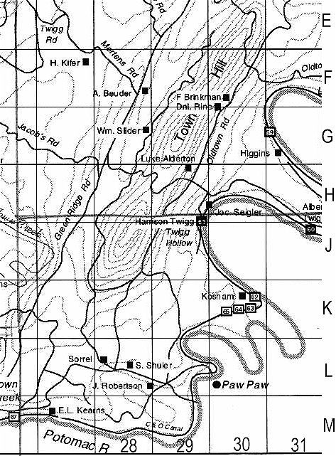
Alderton, Luke 29H
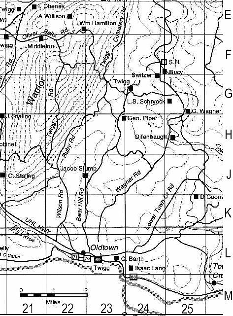
Barth, C. 23L
Baxter 33D
Bender, A 28F
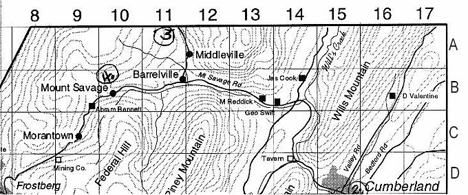
Bennett, Abram 9B
Bucy, D 24F
Callan, Tom's Store 35C
Chaney, I 21E
Cook, James 14B
Coons, D 25K
Cooper, T 20J
Daniels 18H
Davis, John 18J
Dawson, Thomas 2Q
Dell, Wm. 33B
Dicken 19F
Difenbaugh 25H
Foster, John 33B
Greenwald 6Q
Hamilton, Wm. 22E
Hartley 35A
Hartman 19B
Higgins 31G
Hinkle, D 19C
Janson 6Q
Keams, E L 27M
Kelly, Chris 20L
Kersey 7O
Kifer, H. 27F
Kosham 30K
Lang, Isaac 24L
Langley, C 26A
Laught, J R 19J
Loney, D 8G
McElfish 23C
Miller 12H
Miller, J 22B
Morrison Mill 3O
North, John 23E
Piper, Geo. 23H
Piper, John #7 24B
Price, Geo. 34C
Rawls 11L
Reddick, M 13B
Ress, Wm. 9F
Rice, J. 18A
Rice, L. 20D
Rice, S. 18B
Riser, A. 13G
Rizer, J #3 11A
Robertson, J 28L
Robinet 20H
Robinet, Geo. 22B
Schryock, L S 25G
Seigler, Joc 30H
Shaw, Wm. 3M
Shetzer 20K
Shuler, S 28L
Slider, Wm. 28G
Sorrel 28L
Speelman #2 15E
Stalling, C 20J
Stalling, J H 18J
Staupe, W 8G
Stoller 11J
Stump, Jacob 22J
Sweitzer 24F
Swift, Geo. 14B
Taylor, W 3Q
Thomas, Geo. 5K
Tollhouse #5 11F
Trimble #4 10B
Twigg 23L
Twigg 24G
Twigg, A 21E
Twigg, Albert 31J
Twigg, Brice #1 18K
Twigg, Harman 33G
Twigg, Harrison 29H
Twigg, O 21F
Valentine, D 16B
Wagner, C 25G
Welch, R 18A
Wiglick 24D
Wilhelm, A #3 11A
Willison 23C
Willison, A 22E
Willison Stonehouse 23A
Willison, Wm. #6 23A
Wilson Mill 23D
Witt, J #3 11A
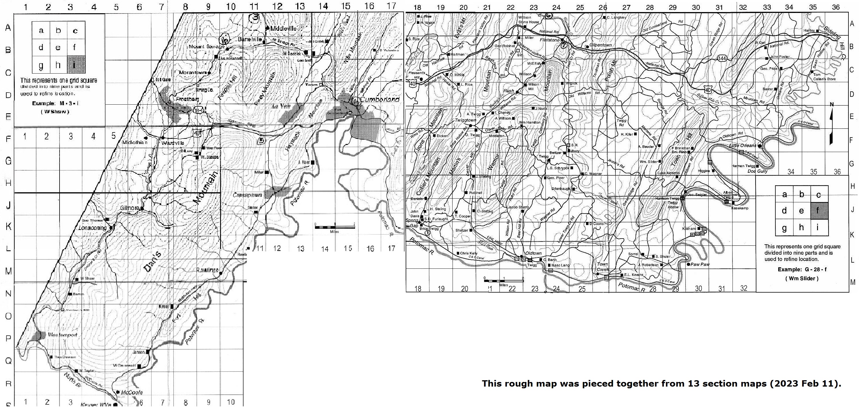
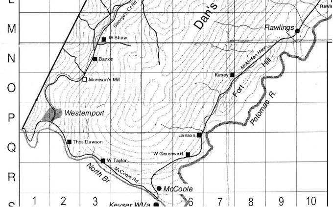
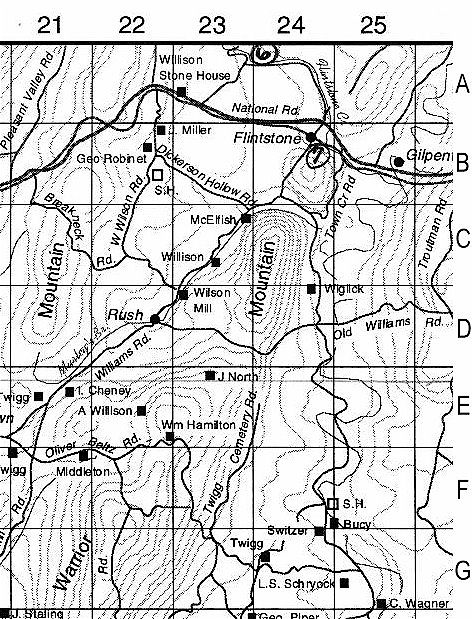
Sharon Banzhoff contributed the maps for the benefit of this project. The maps
contain data compiled from a map of Western Maryland c. 1860 obtained from the
National Archives. Roads are current and not those of the earlier map.
Jerry Twigg prepared the maps for presentation, including the index.
Connie Beachy gathered additional names to add to the maps and typed the revised
index.
Chris Beachy, Connie's talented son, scanned the map portions for
presentation in this project. They both gave up a significant amount of time on
Thanksgiving to provide the images for this project.
Thanks a million to
all of you!
Allegany County MDGenWeb Copyright
Design by Templates in Time
This page was last updated
12/02/2023