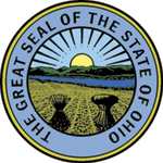
The State of Ohio has had an official seal for more than 150 years. Over that time period, the Ohio government has modified the seal. The current state seal became official in 1996.
The seal illustrates Ohio's diverse geography. In the background stands Mount Logan, in modern-day Ross County, Ohio. Separating Mount Logan from the rest of the seal is the Scioto River. In the foreground, a freshly harvested wheat field exists. In the field, there stands a wheat bushel, illustrating Ohio's important contributions to and traditional dependence upon agriculture. Next to the wheat bushel stands seventeen arrows that resemble the wheat bushel. The seventeen arrows represent Ohio's Indians as well as the fact that Ohio was the seventeenth state to join the United States of America. At the top of the seal is the Sun, with thirteen rays protruding outwards. The thirteen rays represent the original thirteen colonies that rebelled against Great Britain during the American Revolution. Early versions of the seal also had a canal boat, but the modern-day version removed this item.
It appears that the idea for the original Ohio seal originated during the early 1800s. According to many scholars, the seal was based on the eastern view from Thomas Worthington's home, Adena, located near modern-day Chillicothe. Worthington was Ohio's first United States senator and also served as the sixth governor of the state. Today, Adena is a museum operated by the Ohio Historical Society.


MAPS


Map History Site information about maps and mapping
England and Wales digital scans of late 19th century Ordance Survey maps
European Maps complete sets of maps from old atlases 1790-1914 for the United Kingdom and Europe
MAPCO quality scans of 16th to 19th century maps and plans of London and British Isles county maps
Fact Sheet Using Maps in Genealogy--provided by the US Geological Survey
Census Maps of Jefferson County 1790 - 1930
1871
Jefferson County Maps broken down into townships & includes the landowners name
1750-1900
images of Old American atlases
1895
Ohio County Maps
Land Patent Search BLM GLO Records
Formation Maps of Jefferson County 1788-1888
Maps
Jefferson County Map of 1856 broken down into Townships with the landowners name
Migrations Project
Ohio Digital Map Library
The US GenWeb Archives Digital Map Library
Maps over 10,000 digitized online maps covering every part of the globe--This site is awesome as it shows all the schools on the maps and old towns no longer in existence with loads of other wealthy information!


Copyright © 1999-2006 OHGenWeb and the Jefferson County Contributors. All rights reserved.

This site may be freely linked to but not duplicated
in any fashion without my consent.


COPYRIGHT NOTICE: These electronic pages may NOT be reproduced in any format for profit or presentation by other organizations or persons. Persons or organizations desiring to use this material, must obtain the written consent of the submitter or their legal representative, and must contact the listed Jefferson County OHGenWeb Coordinator(s) with proof of this consent.


Back to Homepage


Links to sites that are not part of the USGenWeb Project are provided for your convenience and do not imply any endorsement of the sites or their contents by the USGenWeb Project or its members. Neither the USGenWeb Project nor its members are responsible for the contents of any "third party" site which you may access from a link on this page.


"