|
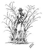
The Caney Run
An Early Trade and Mail Route of the |
|
|
THE "SUGAR BOWL" in
Texas was the fertile land between the Colorado and Brazos Rivers
and especially the land on either side of Caney Creek, from the
source near Eagle Lake to where it terminates near Sargent. During the days of Stephen F. Austin, sugar mills dotted the creek from Hawkinsville to Egypt and the trail which transversed the Sugar Bowl came to be known as "Caney Run." The canebrakes which grew along Caney Creek, once known as "Canebrake River," were very dense, often thirty-five feet wide. Scarcely a tree was to be found in this ocean of cane, which received the name "Great Prairie Canebrake."
|
|
|
|
|
|
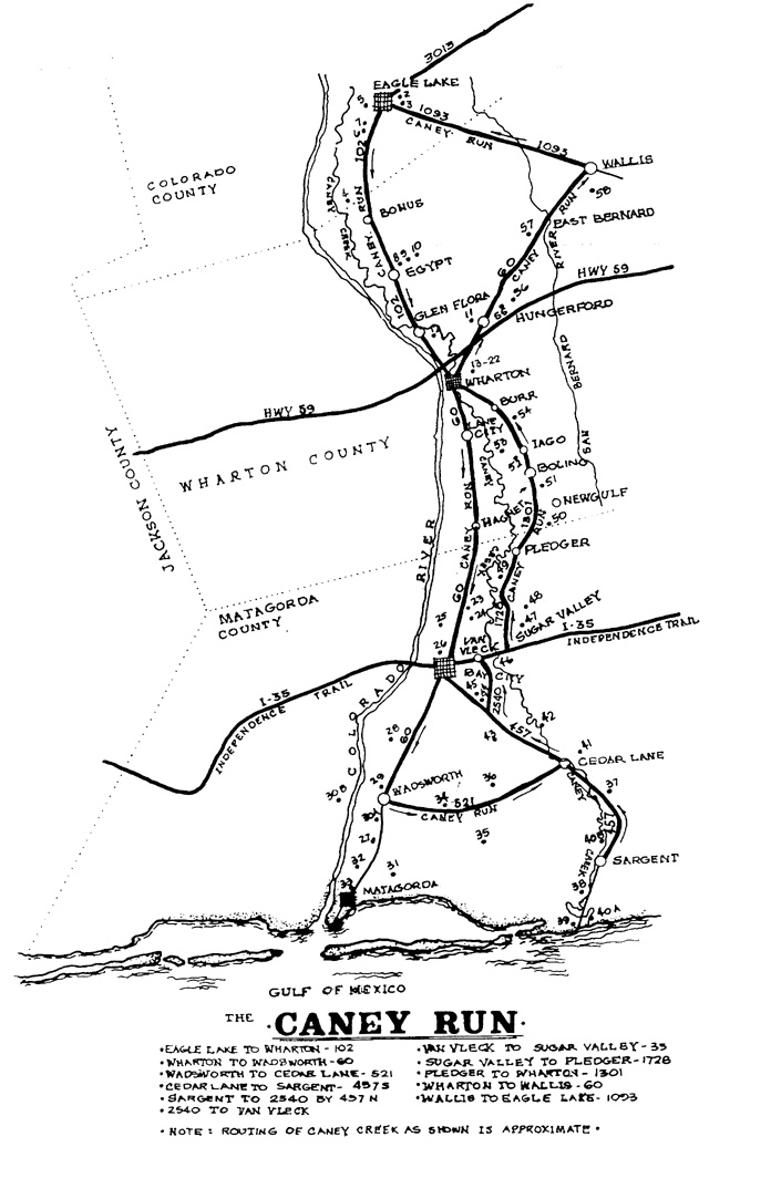
EAGLE LAKE 1. Attwater Prairie Chicken National Wildlife Refuge FM 3013 2. Prairie Edge Museum 3. The Farris 1912, a restored hotel 4. Thatcher-Montgomery Cemetery (1836) (Marker) Located on 950 1/2 mile off 102 5. Masonic Cemetery (1867) Burial place of U. S. Congressman J. J. Mansfield 6. Lakeside Sugar Refinery Site (Marker) 7. Lakeside Cemetery (1873)
EGYPT 8. Historical Marker for the community 9. Northington-Heard Museum (Tours by appointment) 10. Red brick ranch house
SPANISH CAMP 11. Campsite of Mexican troops during the Texas Revolution
GLEN FLORA 12. Sanford Plantation home on Spanish Camp Road (Marker)
WHARTON 13. Monterey Square designated courthouse site 1846 14. Wharton County Junior College 15. Former Shearith Israel Synagogue - Built as a perfect Star of David 16. Wharton County Historical Museum - Permanent exhibit of Indian finds in city and county 17. City Cemetery - 77 Confederate Veterans' graves; 5 graves dating from Republic of Texas 18. G. R. Hawes home (Marker) (Not open to the public) 19. Hamilton Home (Marker) (Not open to the public) 20. Cline and Cline Law Office (Marker) 21. Williamson Marker 22. City of Wharton Marker
WHARTON COUNTY LINE TO BAY CITY 23. Runnells-Pierce Ranch on left 24. Santa Fe Railway 25. First Rice Field in Matagorda County 26. Historical Courthouse Square - Bay City A. Ira Ingram Marker B. Town of Matagorda Historical Marker C. Matagorda County Marker D. U. D. C. Civil War Memorial (1913) & Matagorda County War Memorial (1986) E. First County Officials Marker
BAY CITY TO MATAGORDA VIA WADSWORTH 27. Historic cattle drive followed this road from Bay City to Matagorda each Spring and Fall (100th and last cattle drive was in April, 2008.) 28. Rice fields which have been farmed since 1901 29. St. Francisville Catholic Church and Cemetery on FM 521 & Sacred Heart Catholic Church (Markers) 30A. Equistar Plant 30B. South Texas Nuclear Project 31. Site of Old Gulf sulphur plant and community 32. Selkirk Island Historical Marker 33. Matagorda Historical Markers
A. Matagorda
Cemetery (1830) (Marker) & National Register of Historic Places B. Battle Island Marker (Marker) C. Dale-Rugeley-Sisk Home (Marker) D. Culver-Mecklenburg Home (Marker) E. Christ Church, Methodist Church and St. Peter's Missionary Baptist Church markers F. Old Post Office (Marker) G. Jane McManus' Dream Colony (Marker) H. Early Texas Freighting (Marker)
WADSWORTH TO CEDAR LANE 34. Early mail route from Brazoria to Matagorda 35. Hawkins Plantation Home on Lake Austin 36. Sheppard's Mott - Site of early plantation and stopping place for travel
CEDAR LANE TO INTRACOASTAL CANAL 37. Gainesmore, a ghost town on Caney crossing and named for John Gaines and D. P. Moore 38. Cemetery of the Freeman and Sargent Families 39. Proposed town of Manhattan at mouth of Caney. All early vessels paid toll here. 40A. Civil War - Fort Caney Historical Marker 40B. Sunken Confederate Stern Wheeler, visible in Caney Creek at low tide
CEDAR LANE TO VAN VLECK 41. Cedar Lane was site Power Brothers' Sugar Houses on Caney Creek in 1848 42. Rugeley Community - Site of Robert H. Williams' Plantation and third cotton gin in Austin's colony 43. Caney Post Office Centennial Marker 44. Caney (Matthews) Cemetery 45. Bay City Municipal Airport 46. Site of Old Hardeman Post Office at Van Vleck
SUGAR VALLEY TO PLEDGER 47. Site of early plantation home and sugar mill 48. Cook's Island Post Office (1838) Ghost Town 49. Podo, named for an African slave - Switch on SP on Duncan Ranch. Ghost Town
NEWGULF 50. Former Texas Gulf Sulphur Mining and Cogeneration Plant
BOLING 51. First Methodist Church, designed by famous architect. Nicholas Clayton
IAGO 52. G. C. Mick Home Marker (Known as the Brockman Home) (Not open to the public) 53. Preston Cemetery - enclosed and dedicated by Boling Junior Historians for first town in southern Wharton County (FM 1096)
BURR 54. Burr Albert Harrison Home (Marker)
HUNGERFORD 55. Historical Marker for Hungerford, Quinan, J. D. Hudgins Ranch, and West Post Bernard
EAST BERNARD 57. Holy Cross Catholic Church (stained glass windows, mosaics, and carvings from Europe)
WALLIS
58. Guardian Angel
Catholic Church on FM 1952 (Marker) |
|
|
EAGLE LAKE -- As early as 1819, some of Moses Austin's colonists settled in Colorado County, one of the most historic in Texas. Eagle Lake is located on land granted to Stephen F. Austin's colonists. Its name is supposed to have come from an Indian legend about a princess who was to choose between two suitors by having them cross the lake, climb a tree, and return with a young eagle. The town is the center of the rice-growing industry and is known as the "Goose Hunting Capital of the World." A Waterfowl festival is held each November.
|
|
|
BONUS -- A farming community founded in 1896, once had a sugar mill worked by convicts.
EGYPT -- In 1827, at a time of crop failures all around, Egypt, as its Biblical namesake, provided corn for those who had none. Famous Texans who once lived in Egypt were William Menefee, signer of the Texas Declaration of Independence; W. J. E. Heard, hero of the Battle of San Jacinto; Eli Mercer, member of the founding board of Baylor University; Major Andrew Northington, who helped settlers in the Runaway Scrape; and Gail Borden, editor of the Texas Telegraph and Register and inventor of condensed milk. During the Runaway Scrape, Heard family treasures were hidden in fake graves in the yard of the home. The Heard-Northington Museum is in the old Santa Fe Depot behind the house.
GLEN FLORA -- "Glen Flora" was the name chosen by William Hood for his first Wharton County home, the former Sanford Plantation. It was also the name given to the town, which was laid out in 1900. From the first land grants in the 1820's, farmers have grown cotton, corn, vegetables and grain. Once the major crop was sugar cane and a large sugar mill was located across the Colorado.
WHARTON -- Wharton county was formed in 1846 from Matagorda, Jackson and Colorado Counties. Many of Austin's original colonists had land grants in the county. The county and town were named for two brothers famous in early Texas history, William H. and John A. Wharton. William Kincheloe donated land for the town and Virgil Stewart surveyed it. The block set aside for the courthouse was named Monterrey Square. Albert Clinton Horton, first Lieutenant Governor of Texas, had a plantation here; Robert McAlpin Williamson "Three Legged Willie," brilliant orator and judge, presided over many important cases in Wharton and died at his father-in-law's home here in 1859. In 1930 his body was moved to the State Cemetery. Abel H. "Shanghai" Pierce established ranch headquarters across the Colorado. Today Wharton has a regional medical center and a junior college. There are twenty churches, the oldest being the First Baptist Church, organized in 1847. Wharton is the hometown of playwright Horton Foote and birthplace of Dan Rather.
LANE CITY -- Named for Johnathan Lane, it was established in 1902 and became a center for the rice-growing industry. At one time, it claimed the world's largest irrigation pump.
MAGNET --
Some say that Magnet was so named because developers hoped the
fertile land would draw settlers; others say the saloons were the
magnet for patrons from "dry" areas. Rich oil fields were discovered
in 1937. |
|
|
BAY CITY -- County Seat of Matagorda County was founded on Bay Prairie in September, 1894. Two miles to the west is the Colorado River bridge, an early ferry crossing known as Cayce's Ferry and later Elliott's Ferry. Six miles to the east is Caney Creek. Early mail route from Texana to Brazoria followed this route. Beautiful courthouse built in 1965 has several historical markers surrounding it. The Matagorda County Museum is on the square in the former Post Office building.
WADSWORTH -- Located at the junction of Highway 60 and 521 is an area owned by farmers and cattlemen who came to Texas as early settlers. Named for the pioneer Wadsworth family who were in Matagorda by 1836, the town is on the Santa Fe Railroad and near the South Texas Nuclear Project.
MATAGORDA -- An important early port at the mouth of the Colorado River. Founded in 1829, the early settlers were prominent during the Republic and early statehood. Christ Episcopal and First United Methodist are two of the oldest churches in Texas. It is in the shadow of the nuclear power plant and near the jetties on Matagorda Peninsula.
CEDAR LANE -- On the banks of Caney Creek. It was on the Southern Pacific Hawkinsville tap and was the center of sugar cane production before 1860. At that time it was called Sugarland, later Bowieville. Sugarland had a Post Office as early as 1847 when Thomas Jamison was Postmaster. Caney Creek was navigable during the era of the sugar cane's productive years and was the means of getting the product to the Matagorda Port.
HAWKINSVILLE -- A ghost town on FM 457. The plantation home of James Boyd Hawkins, sugar baron of the mid 1840's is the only evidence of its existence. It once boasted a general store, sugar mill, cotton gin and brick yard. The family cemetery is a well-kept gem sheltered by the guardian pecans and oaks, planted by those who lay peacefully sleeping there.
SARGENT -- A small community named for John Sargent who died in the 1875 hurricane. Once a hub for cotton, sugar and cattle production, it now attracts fishermen, hunters, and pleasure boaters who enjoy its lush prairies, beaches and the wide, verdant Caney Creek.
INTRACOSTAL CANAL -- The waterway connecting Apalachicola, Florida to Brownsville, Texas was begun in 1912 and completed by the end of World War II. This opened the southernmost tip of Texas to barge traffic from points as distant as the Great Lakes and Florida.
VAN VLECK -- Once known as Hardeman's Post Office. In 1900 a townsite was developed which settlers named after the Southern Pacific Railroad Superintendent, W. G. Van Vleck. A small railroad, the first in Matagorda County, had pushed into Van Vleck by 1899.
SUGAR VALLEY AND ASHWOOD -- An area of early Texas plantations and sugar mills on Caney Creek. Ruins of a sugar mill are located near Highway 35 and FM 1728. The mill was in operation from 1904 - 1922 and bricks for it were made on the Bouldin Plantation. Sugar cane and ash wood were shipped by gondolas to market.
PLEDGER -- An agricultural community named by Dr. J. W. Brown in memory of his deceased wife, Narcissa Pledger and her parents. It has been served by a post office since 1880.
|
|
|
DON TOL -- After the Civil War, brothers William Toliver and Solomon Tyre Taylor made an agreement with Green C. Duncan to clear the land of bamboo cane in return for some acreage for themselves. From assets of a silver dollar and a twenty-dollar gold piece, they built their holdings to 12,000 acres. The name "Don Tol" was given by Mexican laborers to Toliver Taylor.
NEWGULF -- The Texas Gulf Sulphur Company mined sulphur at "Old Gulf" in Matagorda County before beginning the operation of the world's largest sulphur mine at Newgulf in the last 1920s. The sulphur plant is no longer in operation.
BOLING -- In 1902, when R. E. Vineyard plotted the town, once known as Floyd's Lane, he renamed it Boling for his wife's niece. The discovery of oil and sulphur in 1925 made it a boom town.
IAGO -- In 1888, C. D. Kemp bought and cleared land for the community. A family friend suggested the name and Kemp became its first postmaster. George C. Mick plotted the town in 1906 and gave two acres of land for the school.
BURR -- Burr Albert Harrison of Virginia came to Wharton County in 1859, bought land and developed a large plantation on Caney Creek near present-day Burr. In 1910, Charlie Kriegel gave up the store and post office at Kriegel, Texas, south of the railroad. Gerard Harrison moved the post office to his store on the Boling Road and named it Burr for his father.
HUNGERFORD -- Named for Daniel Hungerford, who, with his sons-in-law, chartered the New York, Texas and Mexican Railroad. The railway reached this site in 1881. It was named the "Macaroni" Line because of the food preference of the Italian laborers who helped build it.
EAST BERNARD -- On the west side of the river, East Bernard is the center of a fertile farming community. The depot, originally on the east side of the Bernard, was moved because the train had to back up and get a running start to cross the bridge. Father Miguel Muldoon had a land grant along the Bernard in 1831. The population was greatly increased by the Czech and German settlers in the 1890's.
|
|
|
AUSTIN COUNTY WALLIS -- Austin County was a part of the capital department of San Felipe under the Mexican government. San Felipe was regarded as the capital of Austin's colony from 1823 to 1836. Wallis was founded in 1875 and was named for J. W. Wallis, director of the Gulf, Colorado, & Santa Fe Railroad.
|
|
|
Commissioner's Court Minutes, June 6, 1846, Page 60 The Houston Chronicle, May 24, 1931, "Texas Sugar Bowl Lived Again." Texas Post Office Papers, 1836-1839, Texas State Library, Austin, Texas 1966 Holley, Mary Austin: Texas Williams, Annie Lee: The History of Wharton County Garver, Lois: "Wharton County Yesterday and Today" The Primeval Canebrake Forest
The Handbook of Texas
This was a multi-county Sesquicentennial (1986) project of the counties of Colorado, Wharton, Matagorda, Austin and the cities through which the Caney Run passed.
Updated for this
website in 2008. |
|
|
|
|