Many of the communities listed below flourished and died; yet some remain in existance today. Those in italics no longer exist. Additional information underlined is from the Handbook Of Texas.
Antioch - The first church was built in 1866. Located near Van Zandt Co. line.
Bellview - Tom and Alice POLLARD BELL were early settlers in Bellview. Tom died abt 1895 from blood poisoning caused by an injury he received while fishing.
Bonanza - 2-4-2003 News story by Elaine Nall Bay - Spanish word meaning "prosperity"; located on Rains Co. & Hopkins Co. line. Off State Highway 19 thirteen miles south of Sulphur Springs in southwestern Hopkins County. The site was settled in the late 1860s or early 1870s. The community was originally known as Fowler's Store when M. W. Fowler secured a post office there in 1879. The post office was renamed Cold Hill in 1883 and Bonanza in 1898. By 1885 the town had a gristmill and cotton gin, Baptist and Presbyterian churches, a hotel, a blacksmith, two grocers, and a population of 100. A local public school opened around 1900, and during the 1905-06 school year it had an enrollment of sixty. In 1906 the post office was closed. The census of 1940 gave the population as forty. In 1948 the community had a store, a church, and a two-teacher school. The school was later closed, and in the late 1980s the site of the town was marked only by a number of scattered dwellings.
Boyd -
Bright Star - ("Looking Back..." article, 03 Aug 1989) formerly known as Locust Prairie. Older residents of the community recall the story of pioneer travelers coming through on their way to Jefferson, TX; needing a place to rest, they camped for the night, Having a few drinks before retiring on their beds under the sky, they awoke before dawn and saw the morning star shining so brightly that they remarked, "Look at that bright star!" Deciding that would be a good name for the place, they wrote "Bright Star" on a marker and nailed it to a tree. On Farm Road 2795 six miles southeast of Emory in eastern Rains County. It was founded around the time of the Civil War. During the 1930s it had a church, a school, two businesses, and a population of fifty. The school and both of the businesses closed after World War II. In the early 1990s the church and a community center still remained, and in 1990 the reported population was seventy-five.
Cason Town (Map) - HISTORY Was ten miles southwest of Emory in extreme southwestern Rains County. It was probably first settled after the Civil War and was named for a early resident. In the mid-1930s the settlement had a school and a number of scattered houses. With the construction of Lake Tawakoni in the late 1950s and early 1960s the entire area was inundated.
Center Point - located between Emory and Point.
Cody - located on Rains Co. & Hunt Co. line, just outside of Lone Oak, Hunt Co.
Cold Hill - former name of Bonanza.
Colony - first known as "New Hope"; changed to "Colony" in 1885. Some of the early families that settled here were POWERS, CASE, GILLEY, McGAHEY, McAREE, PARKER, MILIRON, BUTLER, MOODY, HORNE, CAUSE, POSTON, READER, EADS, WALKER, HUTCHINS and THORNHILL. The first cemetery at Colony was the Powers Cemetery, located a short distance south of the Colony Church and cemetery; it is one of the oldest in Rains County. R.N.
REED gave the land for the Colony Cemetery; it was established in 1887 an located next to the Colony Church of Christ. (info. provided by Saundra Burge; thanks to Kathleen Baxter for sharing this with us). On Farm Road 779 eight miles southeast of Emory in southeastern Rains County. It was first settled in the late nineteenth century. By 1904 a three-teacher school had an enrollment of 140. In the mid-1930s the settlement had a school, a church, and a number of scattered dwellings. After World War II, the school closed, and in the early 1990s only a church and a cemetery remained. In 1991 the reported population was seventy.County Line - located on the Rains Co. and Hopkins Co. line. On Farm Road 275 some seven miles north of Emory in northern Rains County. The site was first settled about 1840 by William Garrett. Supplies for early settlers were freighted from Jefferson. The first cotton gin there was built by Sam Matthis and Bill Stamps. After the Civil War, the school that served the community was called Union Valley. During the 1930s the settlement had a church, school, and post office. Its school and post office closed after World War II, and in the early 1990s only the church and a few scattered houses remained. In 1991 County Line reported a population of forty.
Daisey - Daisy was six miles north of Emory in northern Rains County. The area was first settled around the time of the Civil War.qv A post office operated at the site from 1886 to 1904. Around 1900 the area had a mill and a store, but by the mid-1930s the community was no longer shown on maps.
Dougherty - named for R.N. DOUGHERTY, who settled in the area before the Civil War. at the junction of Farm roads 275 and 514, six miles north of Emory in northern Rains County. It was first settled around the time of the Civil War.
During the 1930s the community had a church, a school, and two businesses. After World War II, its school and businesses closed, and in the early 1990s only the church and a community center remained in the area.Dunbar - known as Sabine Pass in the 1890s & established by tie-makers; renamed abt. 1900. Named after Sam AARON's hometown, Dunbar, TN. The community consisted of a post office located upstairs over D.K. YANCEY's house (postmaster was Sam Aaron), George NORTHCUTT's store which was later sold to George YANCEY and then to Edd BULLARD, H.H. BULLARD and Charlie WALLACE . The first church was known as "Zion Hill" and organized by Preacher Al McKAY. Dunbar is just off State Highway 19 some five miles south of Emory in southern Rains County. The site was first settled in the 1890s and was originally known as Sabine Pass. A post office operated there from 1900 to 1904. The application for a post office required a different name, so Sam Aron, the first postmaster, chose Dunbar, probably for his former home, Dunbar, Tennessee. The first church in the community, organized by Al McKay, was called Zion Hill. Children attended school in nearby communities until 1904, when a second church building was used as a school. During the 1930s the settlement had a school, two churches, and two businesses. Its reported population in 1940 was fifty. After World War IIqv the community's school and both of its businesses closed, and in the early 1990s only the church and a high school remained in the area. Dunbar's reported population in 1990 was forty.
East Tawakani - On State Highway 276 nine miles west of Emory in western Rains County. It was founded in the 1960s as a residential community on newly built Lake Tawakoni. In 1970 the reported population was 278; by 1991 the settlement had grown to 433 residents.
Elm - on Farm Road 514 seven miles northeast of Emory in northeastern Rains County, was first formed around the time of the Civil War. It had a school that had an enrollment of twenty-nine in 1904. In the mid-1930s the settlement had a school, a church, and a number of scattered dwellings. After World War II, the school closed, and in the early 1990s only a church and cemetery remained at the site.
Flats - named for the terrain surrounding the area also known as Clark's Chapel; named in honor of Mr. Clark who donated the land for a school. At the junction of State Highway 47 and Farm Road 514, seven miles southwest of Emory in southwestern Rains County. The site was settled around the time of the Civil War. In the mid-1930s the settlement had a school, two stores, and a number of scattered dwellings. After World War II, the school closed, but in the early 1990s a church and two stores remained. In 1990 the reported population was 100.
Freedom - Located in northeast section of Rains Co. close to Hopkins Co. line.
Garrett Hump - Named for the GARRETT family who settled in this area; rests partly in Hopkins County, TX.Ginger - Arch WILLIS opened a lignite coal mine in 1900 & wanted to name the community "Cort" after one of his sons. Named after the odd color of brick which was produced at the Fraser Brick Factory. Ginger is on Farm Road 779 three miles southeast of Emory in eastern Rains County. It was first settled in the late 1870s and became a station on the Missouri, Kansas and Texas line in the early 1880s. The small community, near a large deposit of clay, was reportedly named for the color of the clay. A Ginger brick plant, established in 1880, made bricks for the courthouse in Emory. In 1905 the Fraser-Johnson Brick Company opened a factory at Ginger and began manufacturing and marketing "Ginger bricks." The company later shortened its name to Fraser Brick Company and began producing ceramic tile. It continued to operate until the 1940s, when the clay deposits were exhausted. A post office opened at the community in 1910, when Ginger reported a population of 100, two stores, two churches, and a school. In 1920 the population was estimated as 150. By 1930 the Ginger post office had been replaced by rural delivery from Alba. In 1947 Ginger reported two businesses and an estimated population of fifty. In 1990 it was a dispersed rural community with a population of ninety-six.
Goodhope - located in the northeast end of Rains Co.
Goff - Local news indicates that at the turn of the century there was a community in Rains County known as "Goff", which seems to have been the community later known as Willow Springs. The community may have taken its name from the Goff family that lived in the area.
Gritt - located in the eastern end of Rains Co. and south of Alba and was first call New Hope. It was a large farming and ranching commmunity. Some of the early families were JONES, ROBINSON, MILIORN, BUCHANNON, McGHEE, ADAM, COX, HUDGINS, MORRIS, LEVI, PAYNE, HILL, SWEEDEN, SPANN, JENKINS, SHRUM, BRYFORD, LEWERS, STAPLES, COPPLEY and McLEMORE. Mr. Ben SMITH ran a sawmill, which was operated by a steam
engine, close to the Sabine River, located on a slue called "Sawmill Slue". There was a place along the Shortline Railroad called Fertile City which had large holding pens for cattle that were to be shipped to market. Also a hub factory to make hubs for wagons was located in this community. Mr. Earl LEVI owned & operated a general store at Grit. Near the Sabine River is a place called "Buffalo Wallow"; this is a large, flat area without trees. It was said the Indians came there for salt. The old settlers would take large kettles down there and stay for several days, making salt. Later, since this was a large, clear area, it was used for carnivals and other community activities. A baseball field was also there. As a young man, Dr.
FARRINGTON and his team from Alba spent many hours playing ball there. Big community stews were held, with Mr. Ned LEWERS and others making stew. Leon PAYNE was born and raised in Grit. Although he was blind from birth, he always carried his guitar with him everywhere. Lots of Saturdays he would go to Alba and a crowd would soon gather to hear him sing. He became a well-known county and western singer and song writer. He appeared at the Grand Ole Opry many times. Going south from Alba and after crossing Simpkins Creek, the COMPTON Family Cemetery is located to the south and in the woods; the cemetery is located on the M.E. JONES land. (info. provided by Saundra Burge; thanks to Kathleen Baxter for sharing this with us.).Henry's Chapel - Rains County Leader August 20, 1970
Henry's Chapel was located on land that was given by Mr. Jim Henry, When this writer moved to Rains County the school house was still there. I don't remember when it went the way of most of our rural East Texacania buildings. At the present time the cemetery is the only thing there. Mr. Henry was a leading citizen and has descendants here today.Hermit's Cove - At the junction of State Highway 35 and Farm Road 47, six miles west of Emory in western Rains County. It grew up in the 1970s as a residential community near newly built Lake Tawakoni. In 1990 the reported population was forty
Hogansville - formally called "Ophilia". Name changed about 1905 for Hawk & Jeff HOGAN. The community consisted of a post office run by Mr. SEXTON, general store.
Hooker Ridge - named for the HOOKER family which settled in this area. Some of the early settlers in the area were J.H. HOOKER, T.M. CAIN, John R. McMAHAN, Sam HOOKER, Sam BOREN, Walter HOOKER (1939 Rains County Leader). On Farm Road 513 twelve miles northwest of Emory in northwestern Rains County. It was founded before 1904, when its school had an enrollment of seventy-one. In the mid-1930s the settlement had a school, a church, and a number of scattered dwellings. After World War II the school closed. In 1990 Hooker Ridge reported a population of 250.
Jacksonville Community - African American Community located on Highway 19 near Lake Fork. It was named for the Sol Jackson Family, one of Emory's pioneer African American families. The Jacksonville Church of Deliverance, one of Emory's two African American churches, is located in the Jacksonville Community.
Locust Prairie - named because of the many locust bushes and trees in the area. Early name for Bright Star Community.Lone Star -3 miles north of Point... Dr. Mooring gave land for the Lone Star church and cemetery (1939 Rains County Leader).
Lynch - Some of the early settlers were James H. HUGHES, Richard HUGHES, and James LYNCH. On State Highway 35 eight miles west of Emory in western Rains County, was first settled around the time of the Civil War. A school was in operation there by 1904, when it had an enrollment of fifty-four. In the mid-1930s the settlement had a school, a church, and a number of scattered dwellings. After World War II the school closed, and in the early 1990s only a cemetery and a few houses remained.
New Holmes - according to a 1909 article "New Holmes Dots", they had a school and a church; some of the people mentioned living in the community were Gus Orsborn & Frank Smith. Also known as Smyrna.
Pilgrims Rest - This spot became a favorite camping place for travellers enrout to the leading markets of Marshall, Jefferson & Shreveport; it is also said that it was named for Bro. PILGRIM, one of the 1st Baptist preachers on the frontier.
Pilgrim Rest is on Farm Road 2946 four miles east of Emory in eastern Rains County. It was first settled around the time of the Civil War.qv A school was in operation by 1904, when it had an enrollment of 101. In the mid-1930s the settlement had a school, a church, and a number of scattered dwellings. After World War IIqv the school closed, and in the early 1990s a church, a cemetery, and scattered dwellings still remained. The population was seventy-two in 1990.Point - formerly known as Rice's Point, Sheppard's Point and Flasweed Prairie. The postal authorities named it "Point".
At the intersection of U.S. Highway 69 with Farm roads 47 and 514, eight miles northwest of Emory and sixty miles east of Dallas in northwest Rains County. It originated about 1880 as a flag station and post office on a section of the Missouri, Kansas, and Texas Railroad being built from Mineola to Greenville. Residents proposed the name of Rice's Point, in honor of William Rice, a Kentuckian who had settled the area in the 1840s when it was a part of Van Zandt County. The post office rejected that and several other names because they were already in use. In 1890 Point had fifty residents, a public school, and four churches. On August 28, 1902, ten men, led by newspaperman Isaac Newton Gresham, met in Point and signed a charter to establish the Farmers Educational and Cooperative Union of America. The Farmers Union, as it is generally called, became a national organization by 1905 and enrolled its one-millionth member three years later. The organization became so large that it had to move its headquarters to Mineola because the volume of mail was more than the Point post office could handle. In 1913 Point established the first independent school district in Rains County and erected a two-story brick schoolhouse. Also that year a newspaper, the Point Enterprise, began publication. By 1914 the number of inhabitants reached 600. The Great Depressionqv caused a drop in the Point population from 600 in 1931 to 308 in 1933. The number of businesses likewise fell from twenty-five to eighteen. Point's decline paralleled the demise of the cotton industry in Rains County, where production fell from a near record high of 6,420 bales in 1931 to fewer than 3,000 bales by 1935. In the early 1940s U.S. Highway 69, paralleling the MKT railroad from one corner of the county to the other, was paved. This may have accounted for a mild resurgence in population, which reached 420 by 1943. In 1945 Point had 350 residents and eleven businesses. Through the 1950s and into the 1960s the population remained about 400, and the number of businesses stayed around fifteen. During the mid-195Os the MKT line was abandoned. In 1957 Iron Bridge Dam was constructed on the Sabine River to form Lake Tawakoni, which by the time it reached its fullest extent in 1960 was only four miles from Point. In the late 1960s Point reported 589 inhabitants, as residential development began on the western shore of the lake. The community was also incorporated at this time. By 1970 the lakeside residents had organized themselves and incorporated the town of East Tawakoni. Consequently, the population of Point declined to 419 in the 1970 census. Thanks to tourism and to the town's ongoing role as a local center for agricultural trade, Point continued to grow slowly but steadily throughout the 1970s and 1980s. Two small manufacturing concerns have located in Point, a metal casting plant and a maker of wire products. Point's population in 1990 was 645.Poole - At the junction of Farm roads 514 and 2081, eight miles northwest of Emory in northeastern Rains County. It was settled around the time of the Civil Warqv and named for an early settler. In the mid-1930s the settlement had a church, a school, and a number of scattered dwellings. After World War II the school closed, and in 1990 Poole was a dispersed community with a reported fifty residents.
Prospect - also known as Waskom.
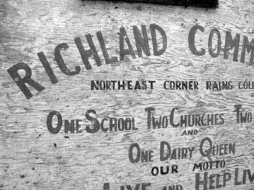
Richland - SIGN A group of settlers stopped at a homestead & asked where a good place would be to settle; they were directed to this area because of its "rich land". On Farm Road 514 seven miles northwest of Emory in northern Rains County. It was first settled around the time of the Civil War. In the mid-1930s the settlement had a church, a store, and a number of scattered dwellings. After World War II the store closed, and in 1990 only a cemetery and a few houses remained. That year the reported population was 100. Only African American Community in Point. It is also where the Richland School was located, the Richland Baptist Church is located, and the Benton Hill Cemeteray is located.
Rocky Point - named for the huge rocks in one spot in the community. Early name was Sweet Home.Sand Flat - named for the flat, sandy land in the area. African American community north of downtown Emory (about two miles). The Prairie Grove Baptist Church (the only African American Baptist Church) and the Prairie Grove Cemetery are located in Sand Flat. The Sand Flat School (which is now closed, but the building is still standing) was also located in the Sand Flat Community.
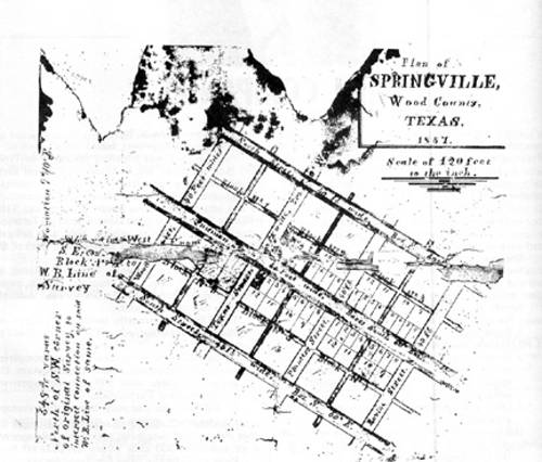
Smyrna - Named chosen by George BISHOP from the Biblical city in Asia Minor. Off Farm Road 2324 four miles southwest of Emory in central Rains County. In the mid-1930s the settlement had a church, a store, and a number of scattered dwellings. After World War II, the store closed, and in the early 1990s only a cemetery and a few houses remained. In 1990 the reported population was twenty-five.Springville - former name of Emory. MAP
Stones Chapel -
Wattsville - 3 miles northeast of Point (now known at Prospect) John Rice WATTS bought land in this area in 1893, building his home in 1895. His family moved from Collin County, Texas, in 1895 to Rains County. Mr. WATTS donated the land for the Wattsville school house and helped start the school. He was a school teacher in Collin County but did not teach at Wattsville School. His son was born in the house in 1898 and lived in the home his entire life. A portion of the original land and the old Watts home is still owned by a granddaughter of John Rice WATTS. Wattsville was on Farm Road 514 seven miles northwest of Emory in northern Rains County. It was settled around the time of the Civil War. In the mid-1930s the settlement had a church, a store, and a number of scattered dwellings. After World War II the store closed, and in the early 1990s only a cemetery and a few houses remained.
Willow Springs - formerly knows as the Reeder Community; the name is derived from the huge willow trees growing along the springs in the area. At one time there was a W.O.W. Lodge with G.W. ALEXANDER as Secretary-Treasurer. The community consisted of a post office located in the George LYNCH Dry Good Store, Frank HARBISON Grocery
Store & Shoe Shop; the W.L. BROWN Drug Store, and the ALEXANDER Gin. Off Farm Road 3274 four miles south of Emory in southern Rains County. It was first settled around the time of the Civil War. A school was in operation by 1904, when it had an enrollment of ninety-three. In the mid-1930s the settlement had a school, a church, and a number of scattered dwellings. After World War II, the school closed, and in the early 1990s only a cemetery and a few houses remained. In 1990 the reported population was fifty.Wolf - the community north of Emory. African American Community located nearest downtown Emory. In fact, the Wolf Community is adjacent to the North downtown area. McMillan Street, named for an African American, is located in the Wolf Community
Woosley - Off Farm Road 47 six miles west of Emory in western Rains County. It was settled around the time of the Civil War. A school was in operation by 1904, when it had an enrollment of 114. In the mid-1930s the settlement had a school, a church, and a number of scattered dwellings. After World War II the school closed, and in the early 1990s only a cemetery and a few houses remained. In 1990 the reported population was forty-seven.
Article from the Rains County Leader - Founding Families of Woosley Community.
Home
