|
Gloucester
County's rich history actually dates from just after the settlement at
Jamestown in 1607. Though the county would not be formed until 1651,
historical events occurred on these lands that were instrumental to the
colony's survival. When the English settlers arrived at Jamestown, the fortress of
Chief
Powhatan, Chief of the
Werowocomoco, was
located on the north side of the river, on land that is now in Gloucester
County. If the legends are true, it was here that
Princess
Pocahontas, daughter of Chief Powhatan,
saved Captain John Smith's life. It was Captain John Smith who proclaimed, "Heaven
and earth never framed a better place for man's habitation," perhaps an early forerunner of "the land of the
life worth living", Gloucester County's motto today.
Some Charles River County land patents
were granted as early as 1639, but the land area that was to become Gloucester County
was not considered safe for settlement until after 1644. George
Washington's great-grandfather received a York County land patent
in 1650 for land that became a part of Gloucester the following
year.
When Gloucester County was formed from
York
County in 1651, it consisted of four parishes: Abingdon,
Kingston, Petsworth, and Ware. (Kingston parish became
Mathews
County in 1791.)
Many believe that the county was named for
Henry, Duke of Gloucester, third son of Charles I. Others think the
county was named for the County of Gloucester in England. "Gloucester"
is pronounced "GLOSS-ter" in New England, but in Virginia it is
pronounced "GLAW-ster", in the English tradition.
These
lands were a major tobacco-producing area in the 1600's and 1700's.
During this time, many imposing plantation homes and grand private estates
were established. A number of these fine colonial homes remain in almost perfect condition.
One of the only eight churches
of colonial Virginia was
Abingdon
Episcopal Church in Gloucester County, and
it is still standing
today. It is believed that both George Washington and Thomas Jefferson
worshipped here, often at the same service. Washington's maternal
grandmother's home (still an active residence today) was in Gloucester,
and Jefferson spent many nights in Gloucester at Roswell, the
home of his friend, John Page. (See the
section on Historical Places for more information about these
places.)
Gloucester's
role during the American Revolution was a pivotal one. The southern
tip of the Gloucester County peninsula extends into the York
River and is directly across from Yorktown. This finger of land,
named
Tyndall's
Point for Captain John Smith's mapmaker, Robert Tyndall,
became known as Gloucester Point at the time of the Revolution. A fortification existed here already, built to protect the waterways
of Virginia. The British Army refortified the point in August
1781, and British forces occupied the point for much of the War.
Gloucester
Point is the site of the "Second Surrender" by
General Charles Lord Cornwallis to General George Washington
at Yorktown.
Gloucester
County's contribution to the history of the colony, the Commonwealth
of Virginia, and to our Nation, has been substantial.
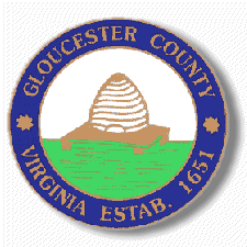
Gloucester County Seal
The Gloucester County
seal was found by Robert Robins, formerly of Ware Neck, Gloucester. It was confirmed by the board of Supervisors in 1974 as the official
seal of the county. Two impressions of the official county seal
were found, though they seem similar, they appear to have been
made from different seals. Both carried the design of a beehive
on a stand in the center of a circular seal with the inscription
Gloucester County Virginia around the rim. Robins found the seal
in the pension application file of Lt. Joshua Singleton of Gloucester,
a veteran of the American revolution. One of the seals was found
on an affidavit sworn on August 8, 1832, and the other was affixed
to a certified record on March 27, 1845. According to a research
conducted by Mrs. Roland Lewis, member of the Historical Committee,
the beehive, is representative of the unity and labor of a colony,
or the unity of a community working together. The use of the
symbol dates back to 407 A.D. |