- About Lunenberg
- African Americans
- Burials
- Census
- Churches
- Miscellaneous
- Families
- History
- Houses & Landmarks
- Land
- Maps
- Marriages
- Resources
- Schools
- Taxes
- Wills
Lee Hall – Land History
Submitted July 4, 2005 by June Banks Evans Copyright © 2005 by June Banks Evans
Bryn Ffyliaid Publications
May be copied only for non-profit, personal use.
Edloe - Barrett – Lowry – Sanford – Baird – Chappell – Cralle – Lee - Lee Hall.
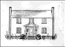
Noted in the 1820 Lunenburg County land tax list as a new house valued at $1000, the historic home of the Henderson Lee family, Lee Hall, was removed from its original site on Crooked Creek in Lunenburg County shortly after the beginning of the 21st century. The land history of this site began in 1751 with a patent of 2000 acres to John Edloe the younger.
In December 1737, the court of Brunswick County appointed Robert Sanford as surveyor of a road from Flat Rock Creek going by the land of Mason Bishop and into Mr. Burch's road. All male tithables belonging to John Edloe, Henry Edloe, Edward Broadnax, and William Kelley were ordered to assist in maintenance of the road. [1] Members of the Edloe family of Charles City County were among early landowners in the western portion of Brunswick County that in 1746 officially became Lunenburg County.
Of particular note are three Edloe patents for land north of the Meherrin River; it is here that the land history of Lee Hall begins:
2700 acres by patent 5 July 1751, both sides Flat Rock Creek PB 30:449
1414 acres by patent 1 June 1750, between Kettlestick Creek and Great Branch PB 30:153
2000 acres by patent 5 July 1751, both sides Crooked Creek PB 30:445
At February Court 1759 in Charles City County, the will of a John Edloe was presented by his executors, and his lands in Lunenburg County were ordered appraised. County records of Lunenburg and Charles City suggest that this John Edloe was married to his cousin Sibella [Cybella] Edloe, daughter of another John Edloe, and she later married Parke Bailey. [2] , [3] , [4] In 1770 John Bailey was said by a Lunenburg County jury to have unlawfully seized the land of the Edloe heirs. [5] This action was followed by settlement of the deceased John Edloe's estate in Lunenburg County two years later on 23 Nov 1772 when the his land in Lunenburg was divided into four lots for his daughters as “impartial” division of the lands. [6] The daughters were Rebecca, Martha, Tabitha, and Alice.
Lot #1 (part of the 2700-acre patent) was drawn by Rebecca (Edloe) Hare, wife of Parker Hare, of Chesterfield County. This lot #1, comprised of 1610 acres with the manor plantation on the east side of Flat Rock Creek, was split and then sold to Edward Pegram and Roger Atkinson, both of Dinwiddie County. [7] , [8] , [9]
Lot #2 (the remainder of the 2700-acre patent) was drawn by Martha Edloe, who died unmarried pre 30 Apr 1785. This lot #2 was divided and passed to her surviving sisters, Rebecca and Tabitha, whose husbands sold the land to John Ballard Jr. [10]
Lot #4 (the 1414-acre patent) was awarded to Alice Edloe deceased, who died prior to the estate division on 23 Nov 1772. This land had been patented by her father as 1000 acres never before granted and 414 acres formerly patented by Joseph Blanks in 1737. This lot #4 was divided among her surviving sisters Rebecca, Martha, and Tabitha. Most of this parcel, lying between Kettlestick Creek and Great Branch [now Broad Branch] was sold to Robert Marshall of Amelia County; 16 acres, to Henry Freeman. [11] , [12] , [13]
Lot #3 was drawn by Tabitha (Edloe) Barrett, wife of William Barrett, of James City County. This lot of 2162 acres was re-patented by Barrett on 24 Jan 1783 to include Edloe's patent of 2000 acres on both sides of Crooked Creek with 439 acres never before granted, a tract of 162 acres sold to Edloe by Robert Briggs in 1750, and another 139 acres as yet unaccounted for – total patent for 2740 acres. [14] , [15] , [16] This lot was then divided into four parcels and sold to Anderson Bagley, Reuben Vaughan, Daniel Taylor, and Thomas Lowry.
(1) Anderson Bagley: A parcel of 762 acres was sold 6 May 1789 to Anderson Bagley by Barrett's executors John Edloe Bailey of Charles City County and John Pierce and Tabitha [Edloe] Barrett of James City County. [17] This tract was on Crooked Creek. In 1792 the land tax records for Lunenburg show that the 762 acres were charged to Bagley, whose estate later transferred 415 acres with a house valued at $500, 10 miles southeast of the courthouse, to his son William Bagley.
(2) Reuben Vaughan: A parcel was sold by Barrett's executor John E[dloe] Bailey to Samuel Watkins, whose son Frederick Watkins sold it in 1815 to Reuben Vaughan as 725 acres situated on the west side of Crooked Creek. [18] This was the part of the Barrett estate taxed in 1821 for a $400 house, 11 miles SE, in possession of Reuben Vaughan. But, by 1828, Vaughan forfeited a deed of trust on his land and residence adjoining Crooked Creek on the east, and this parcel was sold to William Bagley. [19]
(3) Daniel Taylor: A parcel of 648 acres was sold 6 Dec 1791 to Daniel Taylor by John Edloe Bailey of Charles City County and John Pierce of James City County as the surviving executors of William Barrett deceased. [20] This tract adjoined Blanks and Lowry. In 1803, Taylor sold this land to George Jefferson. [21] The deed noted it was bought of the William Barrett estate, adjoining the bridge on Crooked Crk, the land of Rudder, the land of Gee, and Saffold's Road. [22]
(4) Thomas Lowry: A parcel of 607 acres was sold 6 May 1789 to Thomas Lowry by John Pierce and John E. Bailey executors and Tabitha [Edloe] Barrett executrix of William Barrett deceased. [23] The tract was on Crooked Creek, adjoining Ragsdale.
Lowry's 607-acre parcel of the Edloe-Barrett land was soon divided and sold. In 1792, he sold 572½ acres to Abraham Maury and Clark Sanford. [24] The deed describes the parcel as part of the tract bought by Lowry from the executors of William Barrett deceased. The land was said to be situated on Crooked Creek, adjoining Ragsdale, Connell, Bishop, and Daniel Taylor. Two years later, Maury sold his interest in the land to Sanford, who subsequently acquired the remaining portion of the Lowry tract and sold the two tracts as 675 acres to John Baird of Prince George County in 1796 for five shillings. [25] , [26] , [27] The land tax records for Lunenburg County place this property 10 miles southeast (SE10) of the courthouse.
Sometime prior to November 1816, the estate of John Baird deceased was divided and 271½ acres (SE9) were sold to Robert Chappell, Sr., who had married Sallie Garland in 1808. [28] , [29] According to the deed, this parcel adjoined the land of Anderson Bagley Sr., Lucas Gee, William Davis, Edmund Bishop Sr., and land laid off by survey for Elizabeth A. Westmore. In 1820, the first year that land tax commissioners showed value of buildings, it was noted that Robert Chappell was taxed for a new house valued at $1000 on his 271½ acres SE9; the 403½ acres remaining in Baird's estate were SE10, with a building valued at $100, occupied by John Morrison. [30]
Tracking the Chappell parcel in the sequence of land tax records reveals that the value of the house remained at $1000, although from 1827 forward, the location changed to SE10. (The record for 1826 lists the house in value of $100, although in the preceding and subsequent years it was listed at $1000, but the tax calculations are identical each year, suggestive of a recording error in 1826.) Robert Chappell died in the spring of 1826, leaving the property to his underage daughter Elizabeth. [31] This parcel of 271 acres with its $1000 building SE10 and another 126 acres were charged to his estate through 1833.
The Lunenburg County records include a marriage bond dated 9 February 1829 for the marriage of Alexander B. Cralle to Mary E[lizabeth] Chappell. Estate accounts dated 1 May 1828-25 Jan 1829 as filed by the commissioners David S. Garland and Jones Allen on 9 March 1829 for the deceased Robert Chappell mention several expenses and purchases made for his daughter Elizabeth Chappell. [32] , [33]
The Chappell estate was settled a few years later. When the tax commissioner filed the land tax list for 1834, A. B. Cralle was charged with life right in 271 acres and its building SE10 transferred to him from the Robert Chappell estate. The value of the building changed from $1000 to $1500 in 1837. In 1838, Cralle was still being taxed for his life right in that property as well as in fee simple for four other parcels purchased by him, showing his total real estate as 709½ acres. By 1841, an additional 250 acres with a $500 building had been added. [34]
In January 1842, a deed notes that Alexander B. Cralle with his wife Mary E. Cralle sold 1,082 acres to Henderson Lee. The sale involved an exchange of two parcels (952 acres on both sides of Crooked Creek where the Cralles lived plus 130 acres called Frank's Field) for 1,325 acres on Big Hounds Creek owned by Henderson Lee with his wife Susan Lewis Lee. [35] The Frank's Field tract was sold to Sylvanus Ingram that same year. [36] There are cross deeds between Lee and Ingram for 12-15 acres west of Crooked Creek in exchange for 12-15 acres east of Crooked Creek. [37] These conveyance deeds in 1842 established the basis for Lee's subsequent property taxes on approximately 942 acres, including the former Chappell-Cralle home that became Lee Hall.
A Presbyterian minister, the Reverend John Henderson Lee and his wife Susan resided at Lee Hall, east of Crooked Creek. Before his death in 1862, Lee deeded a 342-acre portion and the $500 building to his son John Wimbish Lee. But, by 1869, the entireee Hall estate SE10 (buildings still valued $1500 and $500) was charged to the Rev. Lee's son Major Henderson Lewis Lee, who had married Lucy Scott upon his return from the War Between the States, after being wounded at the Battle of Gettysburg. In March 1894, he was buried with his parents in the graveyard at ee Hall. [38] , [39] , [40]
Shortly after settlement of Henderson Lewis Lee's estate, ownership of the property was conveyed out of the Lee family. A WPA report onee Hall by Mary Boykin lists subsequent owners of the house as J. P. Hazelwood and W. W. Hazelwood. [41] But within a few generations, the sturdy old home lay abandoned, until ca 2002 when Lee Hall was carefully dismantled by Christopher Ohrstrom, an expert in early American decorative arts, and meticulously rebuilt as a home for his family in northern Virginia, near The Plains. [42]
[1] Brunswick County Court Orders 1732-1737, p.149
[2] Benjamin B. Weisiger III, Charles City County, Virginia, Records 1737-1774
[3] John W. Pritchett, Virginians – The Family History of John W. Pritchett
[4] Lunenburg County Deed Book 1:338
[5] Lunenburg County Deed Book 11:327, 374
[6] Lunenburg County Deed Book 12:354-58
[7] Lunenburg County Deed Book 16:72
[8] Lunenburg County Deed Book 18:19
[9] Lunenburg County Deed Book 19:128
[10] Lunenburg County Deed Book 14:260
[11] Lunenburg County Deed Book 12:357
[12] Lunenburg County Deed Book 14:235
[13] Lunenburg County Deed Book 13:35
[14] Land Patent Book W-27
[15] Land Patent Book 27:525
[16] Lunenburg County Deed Book 5:345
[17] Lunenburg County Deed Book 16:205
[18] Lunenburg County Deed Book 24:90
[19] Lunenburg County Deed Book 28:350
[20] Lunenburg County Deed Book 16:190
[21] Lunenburg County Deed Book 19:211
[22] Lunenburg County Deed Book 19:211
[23] Lunenburg County Deed Book 15:443
[24] Lunenburg County Deed Book 16:238
[25] Lunenburg County Deed Book 16:494
[26] Lunenburg County Deed Book 17:83
[27] Lunenburg County Deed Book 17:272
[28] Lunenburg County Deed Book 24:196
[29] Lunenburg County Will Book 8:253
[30] Lunenburg County Land Tax Book 1820
[31] Lunenburg County Deed Book 8:580
[32] Landon Bell, The Old Free State, v2:343, 353, 409
[33] Lunenburg County Will Book 9:382
[34] Lunenburg County Land Tax Books 1834, 1837, 1838, 1841
[35] Lunenburg County Deed Book 32:347-48
[36] Lunenburg County Deed Book 32:440
[37] Lunenburg County Deed Book 32:441-2
[38] Federal census 1860, #612
[39] Lunenburg County Will Book 14:142
[40] Library of Virginia, CSA records
[41] Mary Boykin, Virginia Historical Inventory survey report VHIR/17/0064, 11 Jun 1937
[42] Mitchell Owens, The New York Times, “Mr Phoenix Turns Tumbledown Into Taj,” 20 Nov 2003
Relative links:
Photograph of Rev. Henderson Lee from records of Stephen Israel
Lee Family article