The Weatherford Place
A place called home for over 230 years.
Elevation: 567'
House location: Lat/Long, 078 - 28 - 22 West; 36 - 58 - 39 North.
House faces 191 o which is south southwest
Original house is 28' x 28' or square not counting all of the later add-ons
|
The property and house known as "the Weatherford Place" are situated in Charlotte County near the county line shared with Lunenburg County. The name derives from twentieth-century owners, but this article primarily concerns an earlier owner and his descendants, John Lee Sr. The original tract contained 634 acres which lay partially in both counties.
John Lee Sr. (c.1745-1804/5) is the earliest ancestor traced to date of this family of Lees of Southside Virginia. Several descendants, including this author Stephen Seabrook Israel and Jo Lee Gregory Spears continue to search for information on his origins and ancestry. Family tradition has this Lee family as descendants of Hancock Lee of Ditchley, but the line has never been proved. Elizabeth Lee in her book Virginia Past and Present states that John Lee Sr. was a farmer whose forbears had emigrated from England, settling first in Essex County, then York County before venturing further into the unbroken forests to the west, joining others in opening up enough land to build cabins and cultivate small farms. John Lee Sr. first appears in Charlotte County records as a witness to land sold and recorded June 11, 1772 , and again July 4, 1773 from John Pettis Sr. to his son, suggesting that Lee may well have already been living on, perhaps leasing, land in Charlotte County.
Lee purchased a 634-acre tract from Charles Sallard of Amelia County on August 10, 1773. Sallard had acquired the land from William Hightower's estate in 1764 . Lee pledged bonds worth £150 with a payment due in October 1773, and final installment no later than June 1, 1774. On December 6, 1773, apparently having failed to make the payment due in October 1773, John Lee pledged collateral to Sallard consisting of one "Negro man named Dick", three horses, seven "black cattle", 60 hogs and "my household furniture." Apparently pledging all he then owned, which in the day indicated he had accumulated some wealth, John Lee Sr. secured the purchase, and we may presume that the terms of sale were satisfied by the June 1774 date either by payment, forfeiture of collateral, or a combination of the two. Thus all indications are that the house now called the Weatherford place began as the home Lee built on this land.
The 634-acre tract consisted of two parcels - first, 400 acres bounded as described in a patent dated March 23, 1752 to Joseph Breedlove, and another 234 adjoining acres bounded by trees that had been added by a subsequent owner, Micajar Smithson, who later sold the entire 634-acre tract to Hightower. The location of the tract is depicted in Figure 1 below. The tract is shown as it was divided during the 1800s (as shall be explained below). A dotted line top-to-bottom shows county lines intersecting both parcels, a fact which often has caused confusion as to taxable rights and county location. Both the house known as the Weatherford place, located on the smaller 200-acre tract, and the house known as Woodland, located on the larger tract, are located in Charlotte County. Meets and bounds of these two parcels and approximate house locations are indicated. The tracts are referred to as the Anderson Tract and the Bagby Tract, reflecting subsequent owners of the divided John Lee Sr. parcel and small adjustments to acreage. The two tracts are plotted below by Jo Lee Gregory Spears as they appear in the VaGenWeb Project for Charlotte County, Virginia and include modern day land marks to assist location. By modern roads, Weatherford Place is located .7 miles south of SR 622, .6 miles east of intersection with State Routes 15 and 360 (business) at Ontario.
John Lee Sr. Land Tracts
David Lee Distribution
|

|
Click on the image at left to enlarge and to view details of the Lee tract divided into the Anderson Tract (on the south) and the Bagby Tract (on the north).
|
|
Table 1 |
|
|
On this land the Lee family raised tobacco, livestock including horses, and generally flourished until the mid-1800s. John Lee Sr. farmed and raised his family on it for over 30 years. By 1782, Lee is documented as owning four slaves, five horses and some cattle, a good farm operation for the times. The inventory of John Lee, deceased in 1804/5, reflected the holdings and successes of the average farmer of the county except in regard to horse breeding. John Lee owned a stud horse, several mares and three colts at his death.
By the early 1700s, horseracing had reached great popularity in Virginia, Charlotte County being no exception. Nearly every town had an established annual race. By the time of the Revolution there were 27 important stud farms in the vicinity of the James, York, Rappahannock, and Potomac rivers. In fact, personal property tax records for Charlotte County in 1800 had listed Lee as one of only six breeders in the southern district of the county. Each breeder owned one horse for stud. Lee's tax rate that year was £2.8, computed at twice the covering rate. This rate offers a clue to the value of Lee's stud horse, as the other five taxes ranged from £1.1 to £3, indicating that Lee's stud was second most valued that year. Lee's will valued his "black stud horse" at £67.10 and another horse, which he left to his third son William, at £15. Edward Lee, John's 5th son, carried on the family tradition of horse breeding well into the next century and was taxed for 1 horse standing at stud at $16.67 in 1810 and 1 stud at $16.00 in 1820. At twice the covering rate these horses consistently ranked among the top few breeders in Charlotte County for both periods. At this same period between 1747 and 1806, some 130 miles north and west of Richmond near Warsaw, the Mount Airy stud farm, an eminent horse breeding estate built by the John Tayloe family over several generations, was achieving a fantastic horse racing record. Since 1791, the Mount Airy farm's 141 entries won 113 races. Though not in the same league, John Lee enjoyed the popular sport of the day and participated in the business.
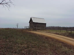
The approach to the Weatherford place is down a long farm road through pasture and farm land. As one approaches the home site, one immediately notices some large oak trees which form a cross if plotted. This stand of trees is located at the edge of a family cemetery and was either planted on or allowed to remain on ground sacred to the Lee, Bagby and Weatherford families. What is most remarkable about this old home is its refusal to die. Wind and rain cry out to reclaim board and batten, but Weatherford refuses to give up to the elements that should have claimed her years ago. Weatherford still provides shelter and warmth to family and friend.
As I studied this old house I was struck by its simplicity. However reflecting the times, I realized that the wealth of John Lee's times lay in his land first, his slaves second, and then his livestock and in his potential to raise the cash crop - tobacco. If one strips away the additions of later centuries, one can envision the small and simple farm house, a working plantation of its day. Elizabeth Lee in her book Virginia Past and Present, accurately described this house as being a small cabin. The original home measures 28 foot square and was called home by a family of eleven in the early years. In describing this same house in Charlotte County Rich Indeed, 1979, the authors comment that there is
.a three cornered chimney and beaded weather boarding. The present tin roof replaced the original wooden shingles. Traditionally, the first glass windows in the eastern section of the county were in this house. The floor plan for the first floor is very unusual. Two rooms are across the front of the house with plain stairs rising between the walls of the rooms. Across the back of the house runs one long room and one of the front rooms has access through this room only. Upstairs there are two rooms.
The chimney collapsed and was removed several years ago according to the current owner, Ed Wallace. The original wooden mantle piece has been saved and is stored in the barn for posterity.
The Weatherford property commands a beautiful view of the surrounding farmland. It is situated on the top of a hill facing to the south. One can easily imagine this same land primarily forested and the challenge to John Lee, who surely had to cut many trees and pull their stumps to plant his crops. This task was accomplished with hand saws, pick axes, shovels, hoes, and mules or oxen. His slaves provided much of this hard labor, but both black and white worked toward the common goal of settling and taming this new land.
At the time of John Lee Sr.'s death, in 1804/05 the original farm had been altered through various land deals and consisted of 596 acres when it passed by Lee's will to his heirs. Thomas Lee was named executor. In 1813 the tract was sold to the Reverend Edward Almond for $1000.00.
Up to the time of the 1813 sale, family members continued to live at the place as the deed reads, "...all that tract of land the said Edward Lee now resides on, it being the same tract of land whereon the said John Lee dec'd [lived] before & at the time of his death containing 500 & 96 acres." Edward Almond died in 1825 and Thomas Lee bought back his father's land in 1837 from Almond's executors. Thomas Lee added on 202 acres purchased from Dr. Giles Harris. In 1848 Thomas Lee and his wife Elizabeth divided the tract, reserving 14 acres for themselves, and deeding 400 acres to son David Lee, and 383 ¾ acres to son John H. Lee. Land records reveal that this small tract of 14 acres eventually was added back to David Lee's inheritance. The following year, David Lee sold part of his land back to Dr. Giles and purchased his brother John's 383 ¾ acres. By ca.1858/60 David Lee had built his new home, the now-standing "Woodland" on the southern tract as shown in 2002. (Click for photograph)
A third generation Lee family residence was located in Lunenburg County on SR 623, Brickland Road and called Lee Hall, home to the Reverend Henderson Lee, son of Ambrose Lee and grandson of John Lee, and his family for nearly 60 years. Common to all three Lee residences are the planting of an orchard of fruit trees - apple, pear and cherry?, English boxwoods and cedar trees at the home-place cemetery site and main house. Reverend Lee was known as the "father of Presbyterianism in Lunenburg County" as explained in the article concerning Reverend Lee published in the Southsider's Number 2, 2001 issue.
Like many Southside residents, after the Civil War David Lee faced bankruptcy in 1871, but managed to hold on to the Woodland farm until 18 Oct 1876, when he and his wife Elizabeth sold the southern tract to Michael Anderson of Armstrong County, Pennsylvania. This southern tract, containing the Woodland house and farm, then situated on 445 acres, remained in the Anderson family for ninety-four years. Land records show that David Lee purchased a small tract in the Drakes Branch area and lived there after he sold Woodland. Nick and Sandra Summers purchased Woodland in 1999, along with the surrounding 52 acres which includes the springs and pond making up the head waters of the Middle Meheren. This description is often referred to in deed conveyances for this property. Since 1999, the Summers have added an additional 15 acres and made many improvements to Woodland.
The northern 200 ¼ acre tract was listed in the 1879 and 1880 land tax records as being owned by Stephen and Catherine Snyder who were originally from Ontario County, NY. These records noted buildings valued at $300. "The village and depot of Ontario was named after the home county of Mr. Snyder." Later, April 1880, Elbert Reed Bagby, a Confederate Veteran, acquired the 200 ¼ acres northern tract, where the Weatherford place stood, from the Snyders for $130.00 . E.R Bagby and his wife Judith had two grandsons named Andrew and Curtis Weatherford who continued to live on the farm up until about 1930 and who owned the land until 1998. This is the origin of the name by which the farm and house have been known for over a hundred years. The family cemetery contains markers documenting in part the Bagby and Weatherford family members buried there.
The Cemetery
Following the conveyance of the Lee tract through a series of land deals including the Snyder purchase, one finds the phrase "all the appurtenances and all the estate and interest therein except the small burying ground for the burial of the dead which lot is not intended to be conveyed by this deed." The cemetery at the Weatherford place apparently was intended to remain in the Lee family, or at least access to it was to be preserved.
The fact that Dicia D. Lee Haskins, a daughter of David Lee, was buried here in 1887, eleven years after the tract passed out of Lee ownership, demonstrates that the setting aside of the cemetery by David Lee was honored by later owners and confirms that Lee ancestors continued to regard this earliest dwelling as their home-place as did the Bagby and Weatherford forebears who are marked as being laid to rest in this sacred ground.
Toward the end of his life John Lee Sr. stayed with his daughter Jane Lee Pearson. On 7 November 1804, he wrote in his will:
.I am now sick at Mr. Joseph Pearsons [sic]and more especially if I should die here, it is my desire that my executor make said Pearson and his family ample Satisfaction for the same.
Beyond providing for financial obligations to be met after his death, John Lee Sr.'s life as a Charlotte County farmer provided a living legacy for Charlotte, Lunenburg, Nottoway and Mecklenburg Counties. The house that is believed to have begun as his pioneer home has endured and is still a family home today. His descendants have become teachers, lawyers, elected officials, ministers, and soldiers who have contributed to progress, education, spiritual well-being, and the civility of Southside Virginia's historical and modern times.
Stephen S. Israel is a 1967 graduate of the U.S. Naval Academy and holds the rank of Rear Admiral, USN Retired. He last served as the Deputy Commander for Mobilization Naval Sea Systems Command, Washington, DC. He has a Master's Degree and is a Professor of Management at the Defense Acquisition University, Fort Belvoir,VA. Admiral Israel resides in Kingstowne,VA with his wife Patricia. They have three grown children, 2 grandsons and 2 grand daughters. The Israels plan to retire and reside in Kenbridge VA in the Spring of 2006 and continue their genealogy research and writing. There house in Kenbridge, Louis Atkinson Hardy House, ca. 1909, has been recently restored and will be open to the public for the Lunenburg County Historical Society Holiday Tour December 3-4, 2005. The home is located at 326 East 5 th Avenue in the newly designated Kenbridge Fifth Avenue Historic District, Virginia Register of Historic Places.
I wish to express my sincere thanks to Jo Lee Gregory Spears for help in writing this article. She manages the VAGenWeb genealogy web pages for Lunenburg and Charlotte counties.
Steve Israel and Jo Lee Spears are Southside cousins as both descend from John Lee Sr.
Contact Steve Israel