

Elko County
NVGenWeb

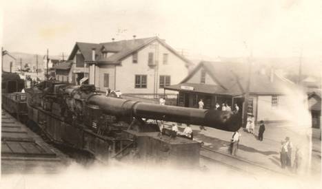
Big Bertha, WWI Canon, came through Carlin in 1923. "It must have been quite an event for my family to go down to take a photo of it."
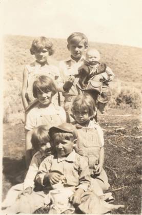
Three Sets of Siblings
1926 or 1927
Top Set - REEL
Family
Middle Set - (my mom & aunt) June & Anona NEAL
Bottom Set -
FITZGERALD Family
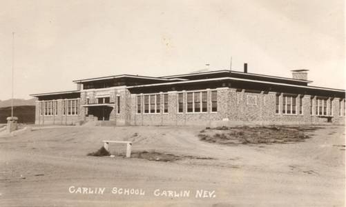
The Carlin School
An early photo of the Carlin School in
Carlin. This building has been demolished to make way for the new school, which
still exists today.
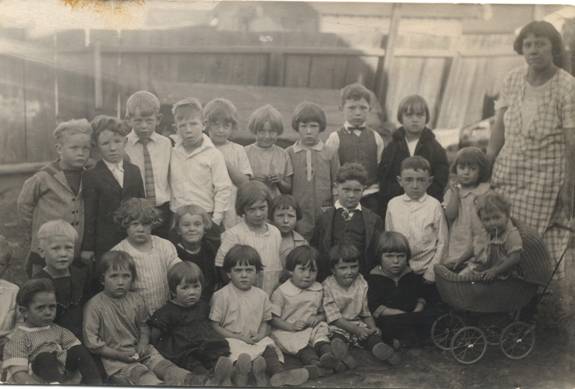
Party in Carlin
1920s
Top Row: Fritz, Vern Archibald, Burt Howard, Eddie Doherty, Alice Doherty,
Vivian Birdsall, Marg McKenna, Tom McKenna, Jamima Cornell.
Middle Row:
Edward Mac?, Lee Taylor, Comeal? Jensen, Alta Mae Barnes, Joyce Jensen, __
Wright, Earl Trowsdale?, __ McBride, June Neal, Mary (Mrs. Grandon) Neal.
Bottom Row: Aaron Martin, Elda Archibald, Marion Jensen, __ McBride, Mary
McKenna, __ McBride, Manning, __ Anona.
Photos contributed by Tami Bakerwell
Carlin received its name from Captain William Passmore Carlin who camped one
and a half miles up Maggie Creek with a troop of men. He was on a military
expedition from Camp Floyd in Utah to California.
The Central Pacific
reached the present Carlin site in December of 1868. Carlin was selected as the
eastern terminus of Humbolt division and a town site was laid out. The original
post office was established on December 4, 1868.
Chinese laborers working
on the construction of the railroad planted gardens and the site was known as
"Chinese Gardens," but when the railroad was completed to Carlin, the name was
changed. The Chinese community was located south of and across the alley form
the present day City Hall. It extended west, to south of the old S. P. (Southern
Pacific) freight house, in the location of the City Club and that area. Most of
the Chinese worked for the railroad, washing engines, pushing the "turntable"
around and other menial jobs. Others of the Chinese community operated stores
and laundries, or they worked as cooks. Very few Chinese women were found in
Carlin.
In the year 1868, the migration of men and their families began
the arrival in the Carlin area. Most of the migrants worked for the railroad in
the shops and in the roundhouse. At this time, the pioneer ranchers came, such
as S. Pierce, C. Boyden, James Clark and T. Griffin. After the arrival of the
Central Pacific Railroad at Carlin, there was much competition among some of the
pioneers in Carlin to build toll roads and enter the stage and freight business.
These freight and stage lines connected the railroad with mines and towns such
as Eureka, Austin, Mineral Hill and others.
Payne, Palmer and James
Russell formed a partnership and opened a stage line over their White Pine Toll
Road in 1869. The road went from Carlin by way of Woodruff Canyon, through Cole
Canyon to Pine Valley to Mineral Hill and other points. The present home of Mrs.
Betty Pearson is still the standing "Stage station!"
The Carlin School
District was created by Elko County Commissioners in 1869. The first school only
lasted a few days as reported by the press:
"Some two weeks ago, one J.D.
Douglas made his debut among us, accompanied by a young and delicate female and
infant. He represented that they were his own darling wife and infant, and that
he was a pedagogue of the first water, and by his smooth oily tongue and
plausible manner induced some of our enterprising citizens to assist him in
buying a canvas house and starting a school. On Thursday last, the woman came
rushing into the railroad office alleging that Douglas had beaten her shamefully
and had threatened to take her life. On investigation, there was disclosed that
she had deserted her husband and two children in Salt Lake City for the "Gay
deceiver." Friday morning found the deceiver chasing the "Star of Empire" in the
direction of Winnemucca and the woman headed for "Brigham’s Paradise," a sadder
wiser woman. The music of the school bell and birch rod have died away in the
quiet city of Carlin and Young America once more has free license to make mud
pies, shie shooting crackers under the feet of spirited horses or tie
belligerent cats’ tails together."
Six months later, on January 1, 1870,
school again opened with Miss Platt as teacher. A school house was erected in
1871 at the cost of $1,500.00 and was built with funds raised by popular
subscription. In 1875, a larger two story brick school replaced the first one
and remained as the school until one was razed in 1909.
The population of
Carlin in 1871 was 800. Carlin had a post office and a library furnished by the
railroad. The library contained 1100 volumes and the reading room was equipped
with lounges, chairs, and a piano. The library burned to the ground in 1879
entailing a $3,000.00 loss.
Carlin was a self-contained community that
found its own amusements and entertainment. Skating parties on the river, dances
and other special entertainment in the winter months. Baseball games and
swimming in the river was the draw in the summer time. Carlin challenged Elko to
baseball games and visa versa. Spectators loyally supported the home team and
seldom was a game played that did not end in a donny brook.
Dances
brought special pleasure and the young folks from Elko often attended. Many
times a "special" was chartered from the Central Pacific Railroad for
accommodating Elko young ladies and young men to attend the dance.
By
1884, a roundhouse, machine shop, four stores, one hotel, two saloons, two
restaurants, two blacksmith shops, one telegraph office, one express office, one
jail were businesses that comprised the town. There was no church but the
Episcopal denomination held services each Sunday and had been doing so since
1881.
On June 29, 1890, Josiah and Elizabeth Potts were executed by
hanging in Elko for the murder of Miles Faucett in Carlin in 1889.
W. F.
Linebarger came to Carlin in 1878 to work for the railroad. Around 1900, he and
William Raines opened a grocery store. Linebarger was an aggressive business man
and not only ran the grocery store, but also the railroad hotel. He built an ice
house on 6th Street and Camp. He cut ice in the winter and hauled it to his ice
house and covered the ice with sawdust to keep it for summer use. By 1910,
Linebarger owned and operated the store, a restaurant, a freight business to
Lynn Creek, a coal business, a dairy, a ranch and a saloon. He later made John
Scott a partner in the store. His son, Zern became his partner in the ranching
operation.
Three men at different times published a town newspaper. The
Commonwealth, started September 8, 1909. The Homebuilder, was a weekly that
ceased publication November 23, 1916. The Nevada Democrat, started in 1917, but
was short lived.
[In 1918, Carlin’s population had dropped to 400 and the town was in a state of doldrums. There was little civic improvement. There were very few trees and few flowers or gardens. The few gardens and flowers that there were, had to be watered by a bucked from private wells. The town slowly came to life and by 1923, acquired a Volunteer Fire Department and one fire engine. The town purchased a power plant from Metropolis for town use from 4 P.M. until midnight each day and also, furnished electricity on Mondays and Tuesdays between the hours of 7 A.M. until noon. This was in order that the wives could wash and iron the family clothes. The present water system was installed in 1935 under the Federal Works Project Administration. Many of the townsfolk and teenagers worked on the job, and all who did were glad to get the work.]
"Carlin in the Beginning" was extracted from the files of "The Old Timer."
Contributor: Unknown
The date of record for the establishment of the community of Carlin is
December 4, 1886. Carlin began in the days of the Central Pacific Railroad's
push eastward towards the linking of east and west with the driving of the last
spike at Promontory Point in May of 1869. The laborers building the railway were
Chinese emigrants who settled and planted vegetable gardens here. These
vegetables were sold to residents and travelers. Thus the community was referred
to as Chinese Gardens.
The town later became known as Carlin, named after
William Passmore Carlin, who was a Union General in the Civil War, and stationed
here in 1863 before the reservation was moved to Owyhee. The word is that the
three creeks around Carlin were named after his daughters - Maggie, Susie and
Mary.
The railroad which began hauling perishables needed a way of
preserving the fruits that were being shipped from the west coast to the east
coast. Ponds adjacent to the tracks would freeze and men would cut the ice with
saws and store the ice blocks in a building nearby. As trains stopped on their
way through, the workers would reload the cars with ice. This method was used
until the mid-1950's.
Since the early 1960's, when modern mining
techniques began being used, mining companies have been the major employers in
the area. With the advent of technology, mining has taken on an even more
important role. Gold is no longer used just in the jewelry industry. It is
necessary for most any of today's conveniences you can name - CD players,
microwaves, computers, aerospace, communications and medical laboratory
equipment.
A part of Carlin's history includes the Overland Stage Station
& the original Carlin Stone House Ranch, both are now private homes. Also the
Carlin Post Office was established December 4, 1886.
Extracted from "Carlin Business Directory." Carlin Economic Development Committee. Express
Publications. Carlin, Nevada. July 1997.
Contributor: Unknown
Prior to the founding of the town in
December 1868, Chinese railroad workers had been sent ahead to the area by the
Central Pacific Railroad supervisor to prepare the land. In keeping with their
agricultural background, some planted vegetables on the Humboldt River so in the
early days the town was called "Chinese Gardens". After the railroad was
completed in 1869, many Chinese were still employed by the railroad for
maintenance and other work until 1890's. The construction and maintenance of the
Transcontinental Railroad was a major contributor to the economic development of
the West. Other Chinese worked as cooks, especially in hotels that served the
railroad passengers, operated boarding houses and did laundry. A small number
were able to farm, providing fresh vegetables and fruits for the neighboring
communities, or work as cowboys and sheepherders. A few Chinese women also lived
in the community.
When the Chinese Minister to the United States, Chen
Lanbin, passed through Carlin in 1876 on his way to Washington, D.C., he
observed three hundred or more Chinese in the town, including wives and
families. They were on hand to greet him.
Census records, which were
always inaccurate especially where the Chinese were concerned, never showed such
a large Chinese population but by 1900 Carlin still had a Chinese population f
note. Three Chinese males worked as cooks in a hotel owned by Samuel Howard. As
in the case of Tuscarora, the Lee family probably dominated the Chinese
community with Sing Lee(born 1862, immigrated 1878) as prominent merchants and
D.F. Lee (born 1854, immigrated 1870) a cook and his wife Ah Quay (born 1852,
immigrated 1885) as other notable community members, all with an ability to
speak English. Wah Lee (born 1862, immigrated 1886) and his partner Tuo Chung
(born 1855, immigrated 1882) operated one of several Chinese laundries in town.
A majority of the men were married, but lived separately from their wives, who
probably could not have endured the hardships of frontier life and/or had to
help support the parents in China.
Like other Chinese communities in
Nevada, the Chinese population in Carlin began to decline rapidly after 1900 and
eventually probably disappeared by the 1920's or 1930's.
By Rev. Geo. H. Greenfield.
Early history of men and affairs in the north-eastern part of Nevada is not lost in
the mazes of time. It has been preserved and is still in the memory of living
men. We are not required to search ancient manuscripts or musty pages. The
transcribing of historical records has not altered the story. Elko County is not
ancient history. The old residents of the County who crossed the plains in 1849
to 1853 in ox-carts still live. Following the trail of Jedediah S. Smith the
first white man to enter what is now Elko County came Kit Carson, the Donner
party, and John C. Fremont. There followed in their trail a few years later
those who came to California during the gold excitement. But few of them still
live to tell the story.
Nothing is more fascinating than an interview
with these sturdy pioneers who have thrilling experiences to relate. To hear
from their own lips what future generations can get only by tradition is one of
the opportunities of the age in which we live. No historian can ever do justice
to the adventures of the first settlers. One by one they are passing. Soon their
voice will be hushed; but while they live, we shall do them reverence and honor
them for the noble sacrifices they have made in redeeming the land. Every day we
partake of the fruits of their labor. The Indians are submissive because they
subdued them; our hills and valleys are productive because they tilled the soil
and turned the streams. They came before the bands of steel made our nation one
united Commonwealth. As we cross our desert in palace cars, it is difficult to
conceive of the hardships that presented themselves to those who came in
ox-carts fighting wild Indians.
Wild West stories are of the past. Those
good old days of long ago before the coming of the wire-fence are but a memory.
Those pioneers, as Kipling said, "built their barns and strung their fences in a
little border station tucked away below the foothills where the trails run out
and stop." Those were the days that tried men's souls. What they have done for
us is one of the debts we shall never be able to pay. For the purchase of land
we can pay the price, but for what these large souls have left us we can never
pay. Two distinct routes of pioneer travel traverse Elko County, one along" the
Humboldt river and the other over the Overland Pass known as the Ruby Summit.
This trail extends over the line into White Pine County. Along that highway,
marked by sobs and groans and broken hearts, that highway made bare by the tramp
of weary feet, there are still a few landmarks left to tell the frightful story.
No history of Elko County would be complete without reference to the pioneers
who, crossing the well-watered valleys of Eastern Nevada on their way to the
Pacific Coast, carried in mind these snow-capped peaks and mountain streams, and
within vision of bright possibilities for such fertile soil, returned again.
There were but few if any who remained in Elko County when they first passed
through. California was the goal, and Nevada the bridge over which they passed.
But those who returned to the valleys of Elko County established themselves so
vitally in its history that their names should not be buried in oblivion.
Elko County with its population of 10,000 lies in the extreme northeastern
corner of Nevada. Idaho lies to the north; Utah to the east; White Pine, Eureka,
and Lander Counties to the south, and Humboldt County to the west. This vast
empire covering an area of 11,000,000 acres is larger than the combined states
of Massachusetts, Rhode Island and Connecticut. One tenth of the acreage is in
the forest reserve controlled by the government. The assessed valuation of the
property of this County is $20,000,000, exceeding that of any other county of
the State. On the assessment roll of the present year are 217,000 sheep, 71,760
cattle, and 11,250 horses. Two banks in the County Seat carry deposits of
$2,000,000. They are capitalized at $100,000 each, while the bank at Wells is
capitalized at $50,000. Splendid school facilities are afforded in its sixty
district schools.
By legislative acts from 1869 to 1875, Elko County was
formally outlined and at the latter date was given its present boundaries. It
was created out of Lander County. Later another portion was taken from Lander
County and given to Elko, thus increasing its size. The last act of the
Legislature affecting the size of the County gave to Eureka County a portion in
the southwestern corner including the mining district of Galena. With the County
Seat at Austin, several hundred miles away, men often took justice in their own
hands. Frequent hangings took place rather than journey so far to the County
Seat.
When the new County was created, Elko was made the County Seat. It
was further provided that 1000 votes should be necessary for the holding of an
election. The total number of votes reported on May 31, 1869, when the canvass
was made was 1,097. On June 21, 1869, the first Elko County election was held
under the direction of Commissioners appointed by the Governor. In the nine
established polling places 473 votes were cast at this first election. A block
of land was presented to the town government by the Central Pacific railroad
company upon which to erect County buildings. Upon that site now stands the Elko
County High School. This fact accounts for the present name of Court street, the
street on which the High School stands. Another selection for the Court House
was made on Idaho street.
By a legislative act of 1874, a State
University was created, the location of which was to be given to the highest
bidder. The population of Elko County at that time was only 3000 and the bonded
indebtedness of the County only four years after its establishment was $112,470.
Twenty thousand dollars of this amount was expended to secure the location of
the State University. The citizens of Elko County donated the land, erected the
buildings, and presented the University to the State. The University building
stands on a prominent and conspicuous location on a rising hill and is now used
for a County hospital. Nearby is the old University dormitory, a large,
well-constructed building opposite the public school building, the property of
C. S. Tremewan. When the University was removed to Reno, Washoe County paid Elko
County $20,000 the original cost of constructing the buildings. The first County
Commissioners were appointed by the Governor in March, 1869. John Wasson, M. P.
Freeman, and Sol. Lewis received the appointment. At the first election on June
21, 1869, the following County officers were elected: — District Attorney, Wm. M.
Gillispie; Sheriff, J. B. Fitch; Clerk, J. W. Stainbum; Treasurer, M. P.
Freeman; Assessor, Wm. G. Seamands; Recorder, R. T. Hafford; Superintendent of
Schools, Dr. M. V. Hudson; Surveyor, E. H. Griswald; Public Administrator, H. C.
Cady. On November 8, 1870, J .B. Moore was elected the first Senator and J. A.
Savage and J. W. Ellyson the first Assemblymen.
Eternal snows upon the
high mountain peaks supply constant streams for the valleys below. The West
Humboldt range, commonly known as the Ruby mountains, protect these snows from
the hottest summer suns. Rocks, trees, and canyons hold back the supply of
water until it is needed to flood the arid lands below. Natural reservoir sites
and many mountain lakes prophecy still further development of land when Nevada's
fertile soil is needed to supply the markets of the world. High altitude limits
production and land values, but diversified farming will do much in the future
to add to the value of land. The most important valleys of this county are,
Lamoille, Pleasant, South Fork, Mound, Huntingdon, Newark, Ruby, Secret, Clover,
Independence, White Rock, and North Fork. The Ruby mountains to the south of the
County seat are high, rough, and rugged on the east and south. They rise
abruptly and are difficult of access. On the north and west they are gradually
approached by low foothills and long canyons. An abundance of water furnishes
good sport for the fisherman for the waters abound in mountain trout. These
mountains are heavily timbered in some places with mountain mahogany, pine,
cedar, quaking asp, spruce, and fur. Being difficult of access, only what is
easily reached is brought down to the valleys for cord wood. The lakes on the
high mountain peaks are some of them 10,000 feet high. Around them are the
eternal snows which never melt. High, rugged cliffs rise abruptly from their
shores and the water is very deep.
Clover Valley was settled as early as
1865 by United States army officers who observed the possibilities of the south
end of this valley while doing duty at Fort Ruby near the old overland trail.
Clover Valley has always been a good cattle country. The residents have
prospered and in recent years have beautified their ranches with neat modern
homes and live in comfort and luxury. The Clover Valley Association has under
its care a public hall, a cemetery, and a public park. A small, neat church
building adds to the advantages of this magnificent valley.
Ruby Valley
is the longest in the State. The ranches are all along one main highway
seventy-five miles in length. The oldest settlers now living in this valley are
Thomas Short, William Griswold, and Isaac Woolverton, the latter having come in
1869. For many years Thomas Short had possession of the Cave Creek ranch in the
southern end of the valley. Here a great underground lake is hid away behind the
hills. A river of clear ice-cold water has cut its way through the rocks. This
case was explored very early in the settlement of the valley by a soldier who
was so elated over his first success that he attempted the second time to go
further into the secrets hitherto concealed from human eyes. His body was found
at the opening of the entrance to the cave the next day. A few years later A. G.
Dawley and Thomas Short, in Search for the origin of some valuable mineral they
had located, attempted a thorough exploration of the cave by taking within the
narrow opening material out of which to construct a boat. They passed from one
huge cavern to another perhaps a quarter of a mile beyond the first opening when
at last they were confronted by a large chamber resembling a pipe organ
arrangement. This they termed the "Great Organ." Of late years no one has had
the courage to enter. The entire cave has not yet been explored. This
underground river and lake is one of the natural curiosities of the State and is
of more than passing interest.
The first white man to bring out a report
of what he had seen within this cave was Hon. A. G. Dawley, now residing in Elko
County. For twenty years he was county clerk and treasurer of Elko County. In
1864 he came to this valley and has been closely identified with its development
ever since. Two large lakes hold the water brought down from the melting snows.
They are known as Ruby Lake and Franklin Lake. In the extreme southern end of
the valley is the site of old Fort Ruby which was located near the old pioneer
trail to Reese River and westward. In this vicinity, as early as 1861, the
Overland Mail and Telegraph Company established stage stations. One year later a
military fort was located here with two companies of the Third California
Volunteer Infantry. This fort continued until 1869, when the troops were moved
to Fort Halleck, which was established July 27, 1869. Fort Halleck lies across
the divide on the north end of Ruby Valley. In 1886 A. G. Dawley was appointed
by the government to auction the buildings of this fort and the troops were
moved to Fort Douglas. The adobe walls of the old buildings of the Fort still
remain. Others were removed to Ruby Valley. The present residence of Isaac
Woolverton was one of the officer's residences.
This valley was the
first one to be settled in the county. The first cabin built in Ruby Valley was
erected in 1859 by William Rogers, better known as Uncle Billy. The first flour
mill built in Elko County was constructed on the Overland Ranch in 1870 and is
still in use. In 1864 the first farming in the valley was done by Colonel Moore
and Lieutenant Gillman. As early as 1865, 1,000 acres were planted in grain in
this valley by the Overland Stage Company on land leased from Mr. Griswold. Here
until the completion of the Central Pacific in 1869 the Overland Mail Company
had a very important station near Fort Ruby. The only relics now extant of this
old fort are a bomb and a U. S. branding-iron in the possession of the museum of
the Elko Y. M. C. A. In Secret Pass, on the north end of Ruby Valley, there has
recently been discovered some exceptionally fine mineral water in what is now
called the Ruby Mineral Springs. These springs were discovered in the fall of
1904 by two prospectors, one of whom, A. S. Coleman, is now vice-president of
the corporation. The location is one of the most desirable in the State for this
enterprise. The scenery is rugged and the climate ideal. The elevation is about
6,000 feet. Snow-covered peaks nearby, over 12,000 feet above sea level, add
greatly to the picturesqueness of the scenery.
Secret Creek, at high
water, used to cover the springs part of the time; the creek has recently been
diverted and the mineral water runs from the solid rock into the creek. The Ruby
Water Springs Company has been incorporated to put the water on the market. This
natural carbonate mineral water was analyzed by State Chemist, Professor
Dinsmore, at the University of Nevada. His analysis showed it to be highly
carbonated and unexcelled by any mineral water in the United States. It contains
a small amount of Iron, Aluminum, Chlorine, Silica, and Potassium and a large
amount of Sodium, Magnesium, and Calcium. The water has a sharp, though pleasant
taste and is as clear as crystal. A short distance above the springs are large
waterfalls from which power will be generated to operate the works and get the
product to market. With a flow of about seventy-five thousand gallons of water
per day this location will become one of the best health resorts in the West. It
is now proposed to construct a sanitarium on the site.
Lamoille Valley,
settled in 1866, has proven to be the most aggressive valley in the county. The
Lamoille Mercantile Company, of which Judge Talbot is one of the leading
factors, has established a business of large proportions. The Lamoille Creamery,
built in 1907 at a cost of $15,000, is one of the most modern and up-to-date
business institutions in the State. It has an annual output of $21,000 worth of
butter. A new church building has recently been constructed by the Presbyterians
at a cost of $5,000. A thriving settlement has sprung up at the crossroads at
the entrance to a long canyon. Several promoters have located the water-rights
in this canyon for the purpose of conveying electric power to the city of Elko.
The first to see the possibilities of this location was W. T. Smith. When he
abandoned it others took it up. But not until the present time has sufficient
capital been available to assure its success. Now enterprising business men have
hold of the rights and are rapidly pushing the project to completion. In the
valley of the South Fork of the Humboldt is a small mercantile business, a
creamery and some very prosperous ranchers.
North of Elko is a valley of
vast proportions traversed by the road from Elko to Tuscarora. This valley is
named Independence from the fact that it was first discovered by a scouting
party of United States soldiers on the Fourth of July. Beyond this on the west
side of the North Fork Mountains is White Rock Valley. Still farther north is
Duck Valley, in which is located the Western Shoshone Indian reservation, about
125 miles north of Elko, with an Indian population of 569. This reservation was
set aside by President Hayes in 1878. President Cleveland added three townships
in Idaho in 1886. Levi Gheen was the first superintendent. He is said to have
spoken Shoshone so well that he instructed the children of the Indians in
Indian. The twelve school buildings cost $30,000 and the sixteen agency
buildings $15,000. The reservation covers 290,000 acres, half in Idaho and half
in Nevada, a well-stocked store is nearby. The Presbyterian denomination, under
its missionary, A. E. Danly, is now constructing a church and manse here for the
spiritual and moral betterment of the red man.
In the mountains to the
east of White Rock the North Fork of the Humboldt takes its rise and flows down
the east side of the mountain through the valley of the North Fork until it
empties into the main stream of the Humboldt near Halleck. Through Independence
Valley flows the only river that runs out of the State of Nevada. This is the
Owyhee. It empties into the Snake and eventually into the Columbia. This entire
northern country is devoted to cattle, horses and sheep and is the best grazing
county in the State. Lamoille and Starr Valleys have developed the bee-industry.
George Bowers, of Lamoille, has 250 stands of bees with an output of five tons a
year of the best honey the world produces. In Pleasant Valley is located the
Elko County Dry Farm Experiment Station, under the auspices of the State
University. In 1909 the county purchased the ranch from John Thompson for
$2,000. The farm is maintained by the State and has already proven its worth.
The board of directors are A. W. Hesson, Professor True and George Bowers.
Very early in Elko County history the mining industry was given prominence.
In 1867 the Tuscarora mines were discovered by the Beard brothers. Never,
however, has the output of the entire county been as gratifying as at present.
The surface has not yet been prospected. So promising are the present locations
that no one dare prophecy concerning the future. When the white man first came
the Indians directed him to deposits of free gold. Since then men have been
seeking the precious metals until many good producers have been found in various
parts of the county. Home capital has developed many of the mines and most of
the money now produced by the county remains to enrich it. Conditions are
rapidly changing. Once men came to Elko County to make a stake and spend it
elsewhere. Now desirable public institutions and handsome residences with all
modern conveniences and sanitary environments offer attractions to people to
remain at home. Sixty millions of dollars worth of the precious metals has come
from Elko County and has added much to our mineral wealth.
Recent
legislation to prevent wild-cat schemes has materially aided the mining industry
of the county. More new properties are being worked to-day than for the past ten
years. Gold Circle, discovered in 1907, is located forty-five miles west of
Tuscarora. Since its discovery seven mines have been developed and three stamp
mills have been built and operated. Seven companies are working at the present
time. At Edgemont, about ninety miles north of Elko, are located the mine, mill,
and cyanide plant of the Montana Gold Mining Company, which owns practically all
the west side of the Bull Run Mountain. There are six miles of underground
workings, which have produced about $1,000,000, chiefly gold. A main working
cross-cut tunnel is now being driven to develop the property at an additional
depth of 500 feet. This will give a total depth of 1,500 feet below the surface
workings. The tunnel has been driven 3,000 feet and is to go 1,000 feet further.
Work is now in progress.
Nestling in the hills of antiquity where Indian
legends abound is the famous camp of the Jarbidge. Nature could not have added
more to the attractiveness of this location. It is in strong contrast with the
camps of southern Nevada. An abundance of timber and water, good feed and wild
game make it a veritable pleasure resort. The camp is only four years old. Boom
days have passed and permanent work established. Many of the mines are being
actively developed at the present time.
Also in the northern part of the
county is Contact, a camp producing copper, silver and gold. A contemplated
railroad connecting Idaho points with the Western Pacific at Wells will enable
this camp to market its ores. From the Copper Queen on Lone Mountain,
twenty-eight miles north of Elko, ore is now being shipped by the Ely
Consolidated Mining Company to their smelters in Salt Lake City. Home capital is
developing Sprucemont, south of Wells. Mardis and Charleston, north of Deeth,
have several producers, on one of which a ten-stamp mill was built last year and
is now in operation.
No camp presents greater possibilities than old
Bullion, reached by easy drive over a good level road from Elko, only
twenty-five miles southward. Here the Nevada Bunker Hill Mining Company is
driving cross-cut working tunnels that will open up these properties 800 feet
below the old workings. Ore is now being shipped from this camp to the Salt Lake
City smelters. All of these camps are being legitimately developed and an
enormous increase in the output of Elko County mines will be manifest in the
next year.
Between Salt Lake City and Reno, a distance of over 500
miles, the largest city is Elko, the county seat of Elko County. It has a
population of 2,000 and is 5,000 feet above sea level. Five hundred and
sixty-seven votes were cast at the last election. At the present time there are
about 400 dwellings, and the city is growing very rapidly. It has been stated
that the name "Elko" was given to the county seat by Mr. Charles Crocker, one of
the directors of the Central Pacific Railroad. Mr. Crocker simply added an "o"
to "elk," because of the large numbers of elk in the surrounding hills at the
time. This gave the town the name "Elko." In 1868 the Central Pacific, which was
constructed from the west as well as from the east, reached Elko. For some time
the present site of the town was the eastern terminus of the road. Thus was
established the town that has grown to its present proportions, the location
having been determined by this mere coincidence of the delay in continued
construction. On May 10, 1869, the golden spike completing the road was driven
at Promontory.
The oldest landmark in the town of Elko is the old
building formerly used as the Pioneer saloon. It was recently moved on the old
Chase estate to make way for the construction of a three-story brick building,
still known as the Pioneer Building. When the railroad was completed the
Overland Stage Company put on a stage-line between Elko and Hamilton and Elko
became the leading shipping point on the railroad. One month after the driving
of the golden spike that marked the completion of the Central Pacific Railroad,
Elko's first newspaper was published. On June 19, 1869, was published the first
copy of the Elko Independent, which is still run under the same name and is
owned by Hon. W. W. Booher. The advertisements and locals of that issue indicate
most prosperous conditions and a most sanguine people. Elko was then a tent-city
of about 2,000 people. Lots jumped within a few months from $500 to $2,000. Such
buildings as were necessary for emergency were rapidly constructed. Elko became
firmly established as an emporium of trade and it was then prophesied that it
would soon become the leading city between Sacramento and Omaha.
The
first child born in Elko of which we have any record was George Elko Gantz, born
July 7, 1869. The oldest living Elkoite is Judge L. E. Morgan, now in his
eighty-ninth year. In 1849 he joined the Odd Fellows lodge at Unadilla,
Michigan. This makes him the oldest Odd Fellow on the Pacific Coast. He has
served two terms -as county treasurer and eight years as justice of the peace.
J. F. Triplett, now living in Elko, claims the distinction of acting as guide
for the first stage that came through the Humboldt Valley in 1858. Elko is well
represented in all the fraternal organizations of the State. A charter was
granted to the Elko Lodge No. 15, F. and A. M., in 1871. At this time they held
their meetings in a brick house near the Humboldt steel bridge. At present this
lodge numbers 145 members. The charter for the Eastern Stars was granted in
1908. It is one of the flourishing lodges of the county. The Independent Order
of Odd Fellows dates back to 1870.
The Rebecca Lodge is of more recent
date, having received its charter in 1898. The Knights of Pythias was organized
in 1883 and is the only lodge in Elko that owns its own hall. It meets in a
brick building, built by Elko Grange No. 9, and is one of the historic
landmarks. Four years ago the Woodmen of the World was established. They hold
regular meetings and have a large membership.
An abundant supply of good
water has been secured in Elko by tunneling .the hills of Kittridge Canyon,
eight miles away. The water is stored in large reservoirs near the town. A new
one is now being constructed. In public buildings the county seat of Elko County
leads the entire State. In 1909 the old public school building of two stories
brick, which was constructed in 1875, was torn down and a new modern school
house erected to take its place. The new one cost $40,000. On September 20,
1869, the cornerstone of the first Courthouse was laid. This building stood on
the corner of Sixth and Idaho Streets until 1910, when it was torn down to make
room for the present building. Additional ground was purchased and a handsome
building was constructed at a cost of $150,000. The following year, on the
opposite corner, the Presbyterian Church constructed a large and beautiful
building, harmonizing with the Courthouse in architecture. This building cost
$20,000. It is' a combination church and Y. M. C. A.
One of the most
important events in the recent history of Elko was the construction of the
Western Pacific Railway. The track-laying machine laid the rails in Elko on the
day before Christmas, 1908. On August 20, 1910, the first passenger train on
this road passed through Elko. It was a newspaper-special and carried
representatives of nearly all the papers of Nevada. The first regular passenger
train passed through two days later. The Western Pacific received a purse of
$10,000 from the business men of Elko to establish here their shops and
roundhouse. At the same time they made Elko their freight division point and
established here their main offices of the eastern division of which R. M.
Ogilvie is superintendent. The Western Pacific employs 170 men in Elko and has a
monthly payroll of $20,000. This road, running south of Salt Lake, runs through
Clover Valley and parallels the Southern Pacific from Wells to Winnemucca. There
is less than a one per cent, grade on the entire system.
In the fall of
1912 the present sewer-system was installed at a cost of nearly $50,000. The
sanitary and climatic conditions of Elko makes it a desirable residence for
those suffering from throat and lung troubles. The Hot Springs Hotel, near the
outskirts of the town, is a veritable health resort. Here rheumatics are treated
very successfully. All blood and skin diseases yield very readily to treatment
in these medicinal springs. A large pool is constructed for the use of
pleasure-seekers. Well-equipped private baths are provided for those who desire
privacy and opportunity to regulate the temperature of the water at their own
pleasure.
Carlin, the freight and passenger division point of the
Southern Pacific, is situated just twenty miles west of Elko. This town was
first settled in 1868 by J. A. Palmer. The present population of the town is
about 650. Business is good and everyone is prosperous. A commodious school of
modern equipment furnishes excellent facilities for instructing the pupils. The
Methodists have a substantial frame building, the pulpit being supplied from
Sparks. A railroad club has a library, reading room, pool room, and bathrooms.
These are furnished and maintained by the railroad, which employs 175 men and
has a monthly pay roll of $15,000. Wells, on the Southern Pacific and Western
Pacific, has a population of about 400. There is a Presbyterian church building
and a manse. Two good hotels furnish accommodations second to none in the State.
The Nevada State Herald is published here. The oldest pioneer of Wells is Uncle
Abner Wiseman. Tuscarora was settled in 1867 by prospectors in search of
placer-gold. In 1868 an adobe fort was built by the settlers to protect them
from the invasions of the Indians. A Methodist meeting-house furnished a
religious home for all denominations for many years. It is now practically
abandoned. Deeth is another railroad town between Wells and Elko. It is the
shipping-point for Starr Valley, a very productive settlement. Here a weekly
newspaper, The Commonwealth, is published by A. B. Gray. A few other towns along
the line of the railroad, the principal one of which is Montello, are shipping
points for ranches and mines north and south of the railroads.
Source: The History of Nevada, Volume 2, edited by Sam P. Davis, published 1913 by Elms Publishing Company, Reno, Nevada, Pages 818-829.
Elko County NVGenWeb Copyright
Design by Templates in Time
This page was last updated 03/08/2024