

Baltimore County
MDGenWeb

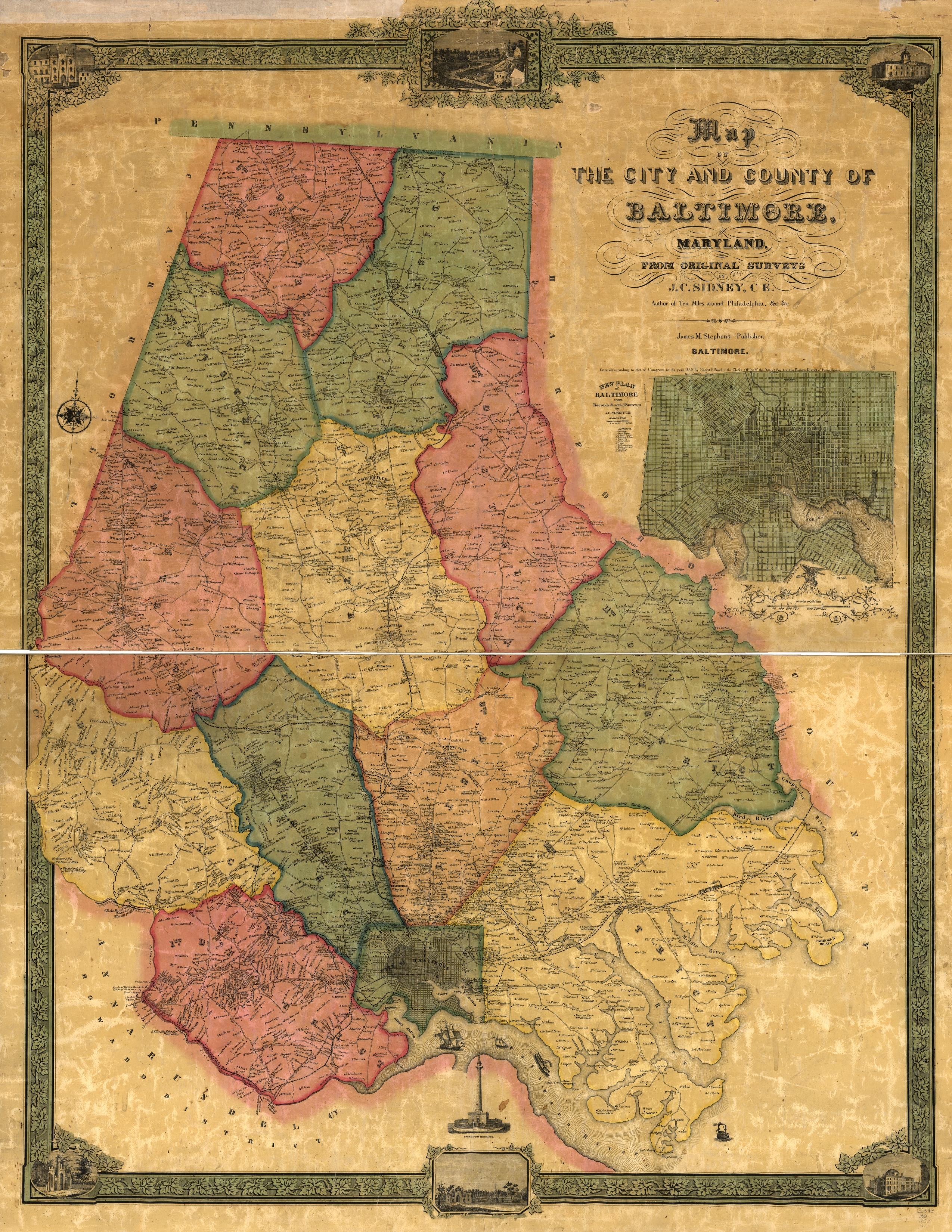
1857
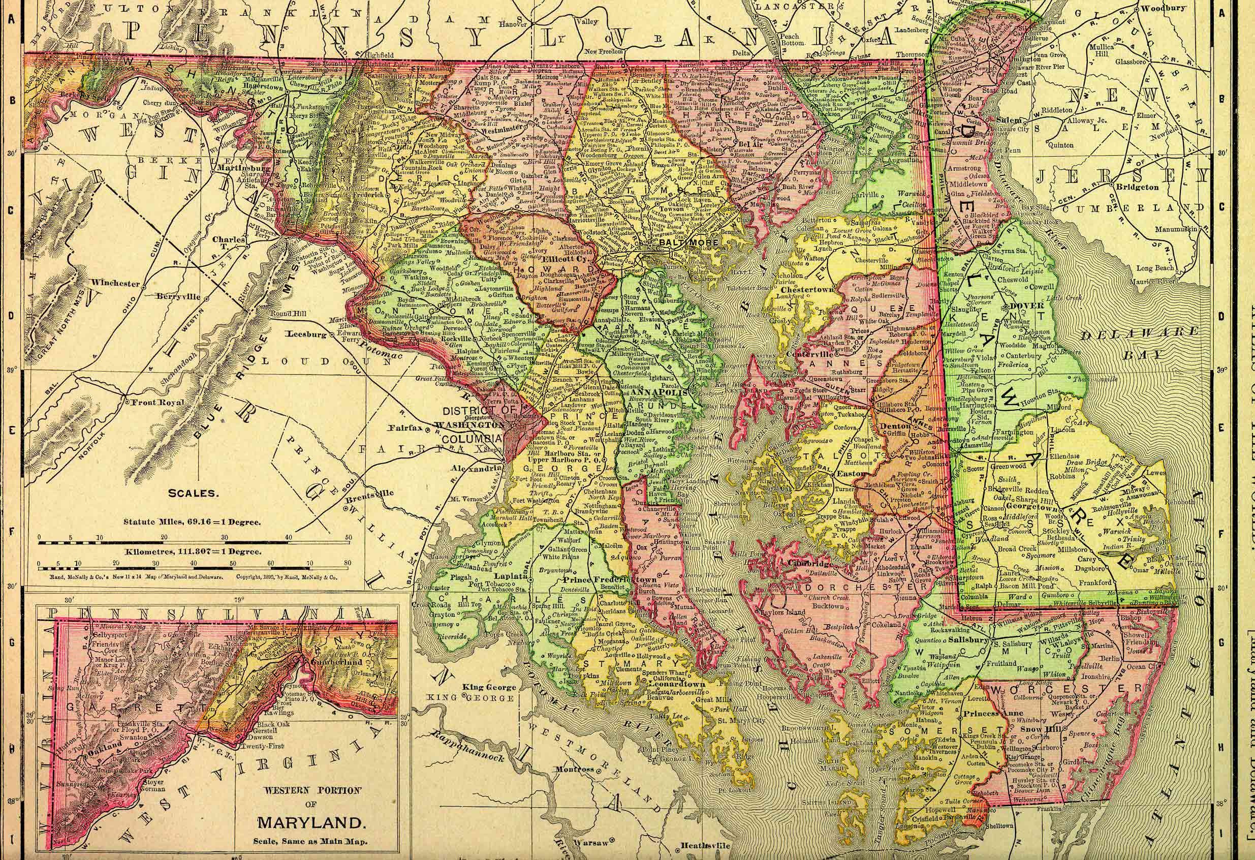
1895 Rand McNally Atlas
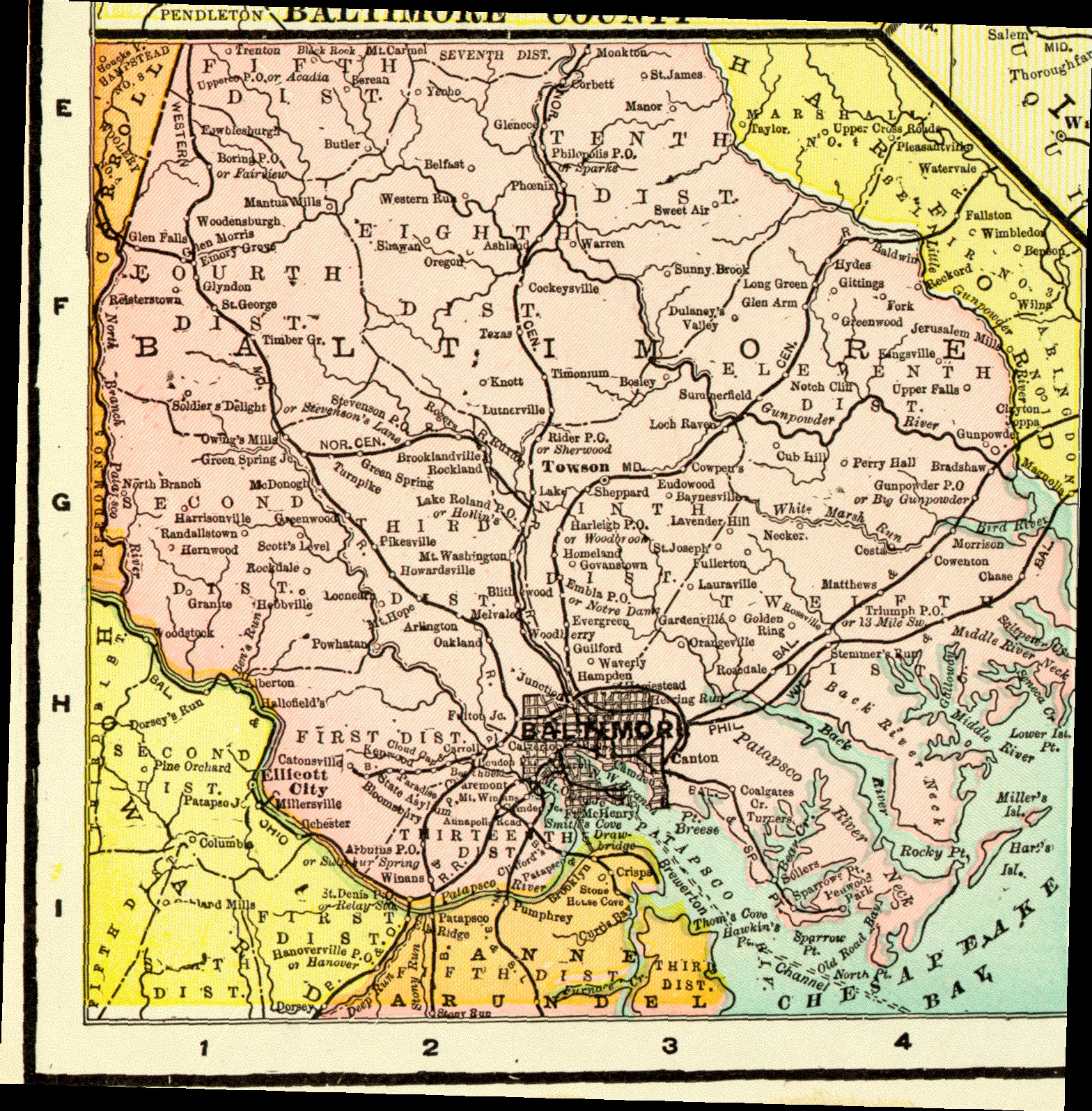
1906
Lower portion of county
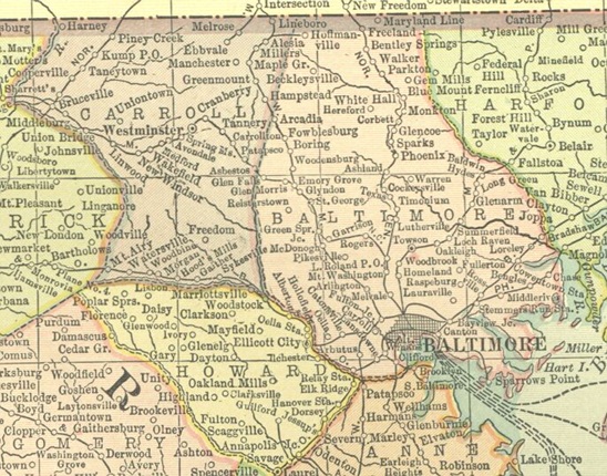
1914 Atlas
1915
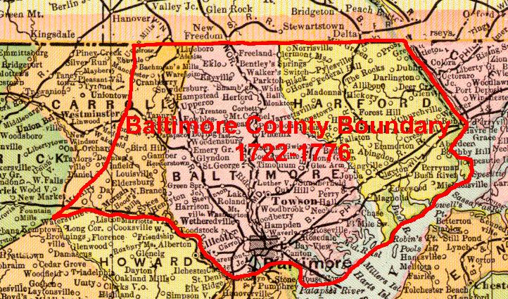
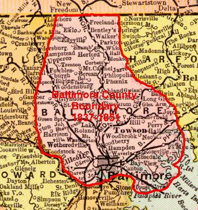
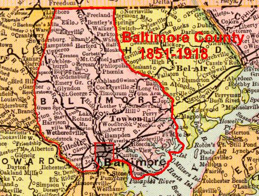
Baltimore County was an original county in Maryland, chartered out of the
wilderness. There is no existent charter or other act for the county, however,
other data indicates that the county was formed about 1659.
The
following maps were prepared from the base of a 1906 Atlas map to show the
changing boundaries of the county over time. In the 17th century, the boundary
between Maryland and Pennsylvania was disputed and not settled until the
Mason-Dixon Line was surveyed in 1763-1767. Baltimore County claimed boundaries
encompassed parts of Delaware and Pennsylvania in the 17th century. The western
boundary of Baltimore County was not well defined until Frederick County was
formed in 1748, parts of Frederick County at that time were considered Baltimore
County, with most of Frederick County coming from Prince George's County (which
encompassed most of Western Maryland). Over the years the size of Baltimore
County has decreased to its present limits, with the last major change coming
from annexation of a large area by Baltimore City in 1918.
 |
 |
 |
 |
 |
 |
 |
| 1659 to 1662 Original estimate |
1662 to 1674 Kent changes |
1674 to 1722 Cecil changes |
1722 to 1776 Anne Arundell & Frederick changes |
1776 to 1837 Harford changes |
1837 to 1851 Carroll changes |
1851 to 1918 Baltimore City changes |
Arbutus
Baldwin
Baltimore Highlands
Beckleysville
Boring
Bowleys Quarters
Bradshaw
Brooklandville
Butler
Carney
Catonsville
Chase
Cockeysville
Dundalk
Edgemere
Essex
Fork
Fort Howard
Garrison
Germantown
Glen Arm
Glencoe
Glyndon
Halethorpe
Hampton
Hereford
Hunt Valley
Hydes
Jacksonville
Kingsville
Lansdowne
Lochearn
Long Green
Lutherville
Maryland Line
Mays Chapel
Middle River
Milford Mill
Monkton
Nottingham
Oella
Overlea
Owings Mills
Parkton
Parkville
Perry Hall
Phoenix
Pikesville
Randallstown
Reisterstown
Rosedale
Rossville
Ruxton
Sparks
Sparrows Point
Stevenson
Timonium
Towson (county seat)
Turners Station
Upper Falls
Upperco
White Hall
White Marsh
Woodlawn
When researching Baltimore county before ca 1820, you will encounter two terms referring to an area of land. One of the terms is Hundreds and the other is Parishes Hundreds as a political subdivision date back to the Roman occupation of Britian. Their are several variations of the orginial meaning of the term. The most commonly accepted is that is was an area that contained 100 families. Another variation is that it was an area that was large enough to raise an army of 100 men. From the late 1600s to early 1800s in Maryland the term was applied as a political subdivision of the county primarily for tax purposes and judicial affairs. The latter being that there was a constable appointed for each hundred and a justice of the peace for each hundred. The 1790 and 1810 Federal census for Baltimore county are at least partially broken down by hundreds. The equivalent term today for a hundred is an election district within the county. Although Maryland was founded by Catholics (the family of Lord Baltimore), its religion was dominated by Puritans in the 1650s and then later the Church of England. In June of 1692 the General Assembly passed an act that essentially established the Church of England as the "state church", required the establishement of parish boundaries and also required each parish to establish a register of births, marriages, and deaths within the province.
When Baltimore county was first settled, there were no roads, except a few indian paths; thus, travel was mostly by water, and you will find persons styled in terms of where they lived. For example in early deeds, people are styled as: William Boulton of Bush River, Richard Ball of Patapsco, John Lee planter of Bush River. The early Hundreds were thus often named for rivers. When Baltimore county was fist formed, its boundaries ran from the ridge dividing the watershed of the Magothy and Patapsco Rivers around to the Sassafras River. Thus it included todays Cecil county, and Harford county, parts of Carroll, Anne Arundel, and Howard counties. Also since the early boundaries were not fixed it probably also extended into Delaware and Pennsylvania. Cecil County was formed in 1674 at which point the northern eastern boundary of Baltimore county became the Susquehanna River. A formal boundary between Baltimore and Anne Arundel county was initially laid out in 1698.
By 1698 is appears there were three hundreds in Baltimore county, the Patapsco Hundred (which ran from the south side of the Patapsco River to the north) the Gunpowder Hundred, and the Spesutia Hundred. The original county seat was at Spesutia Island off the Bush River. Apparently there was a town of Baltimore in this location in 1683. In 1707 the General Assembly directed that a twon be erected on 50 acres called "Taylors Choice" and that the county courthouse be erected there. This land was off the Gunpowder river. However in November 1712 an act of the Assembly directled that the courthouse be erected in the town of Joppa.
There were three parishes established in Baltimore County in the 1690s. These were St Pauls, St Johns, and
St Georges. The parish boundaries roughly corresponded to the boundaries of the three hundreds:
St Paul's Parish was the Patapsco Hundred
St John's Parish was the Gunpowder Hundred
and St George's Parish was the Sesputia Hundred
In 1727 the Boundary between Anne Arundel and Baltimore counties was changed so that all land on the south side of the Patapsco river was to be in Anne Arundel county.
As the county's population grew, new hundreds were created. Also because of the distances to the churches, "chapels of ease" were built. These later became their own parish. St Thomas Parish was created in 1742 and the chaple was built near Garrison Forest as part of St Paul's Parish for the western part of the county, and St James was created at Monkton in 1750 as a chapel of ease for St John's Parish. St James was recognized as an independent parish in 1777.
From the 1737 Tax lists: the Hundreds and Parishes for Baltimore county were:
| Hundred | Parish |
|---|---|
| Patapsco Lower Hundred | St Paul's |
| Patapsco Upper Hundred | |
| Soldiers Delight Hundred | |
| Back River Lower Hundred | |
| Back River Upper Hundred | |
| Middle River Hundred | St John's |
| Gunpowder Lower Hundred | |
| Gunpowder Upper Hundred | |
| Lower Spesutia Hundred | St George's |
| Upper Spesutia Hundred | |
| Deer Creek Hundred |
By 1776 the following Hundreds existed:
| Hundred | Parish |
|---|---|
| West Hundred - of Baltimore Town | St Paul's |
| East Hundred-of Baltimore Town | |
| Patapsco Lower Hundred | |
| Patapsco Upper Hundred | |
| Midlesex Hundred | |
| Back River Hundred | |
| Back River Lower Hundred | |
| Back River Upper Hundred | St Thomas' Parish |
| Soldiers Delight Hundred | |
| Delaware Hundred | |
| Pipe Creek Hundred | |
| Middle River Lower Hundred | St John's Parish |
| Middle River Upper Hundred | |
| Gunpowder Lower Hundred | |
| Gunpowder Upper Hundred | |
| North Upper Hundred | |
| North Lower Hundred | |
| Spesutia Lower Hundred | St George's Parish |
| Spesutia Upper Hundred | |
| Susquehanna Hundred | |
| Deer Creek Hundred |
On 2 March 1774, Harford county was created out of Baltimore county. with the Little Gunpowder river serving as the dividing line between the two counties.
In the Federal Tax assessment of 1798 Baltimore County was divided into the following hundreds:
The other major boundary changes occured in 1837 with the formation of Carroll county from the western part of Baltimore county and the eastern part of Frederick county and in 1851 with the formation of Baltimore City as an entity separate from the county and in 1836. The county also lost land through annexations by Baltimore City, particularly in the early 1900s.
Copyright © 1996 - The USGenWeb® Project, MDGenWeb, Baltimore County

This page was last updated
07/12/2026